IMAGES TAKEN NEAR TO
The Park, LINCOLN, LN4 2EB
Introduction
This page details the photographs taken nearby to The Park, LN4 2EB by members of the Geograph project.
The Geograph project started in 2005 with the aim of publishing, organising and preserving representative images for every square kilometre of Great Britain, Ireland and the Isle of Man.

There are currently over 7.5m images from over14,400 individuals and you can help contribute to the project by visiting https://www.geograph.org.uk
Image Map
Images are licensed for reuse under creativecommons.org/licenses/by-sa/2.0
Notes
- Clicking on the map will re-center to the selected point.
- The higher the marker number, the further away the image location is from the centre of the postcode.
Image Listing (54 Images Found)
Images are licensed for reuse under creativecommons.org/licenses/by-sa/2.0
Image
Details
Distance
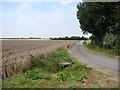
3
Entering Potterhanworth
On a footpath from Nocton.
Image: © Jonathan Thacker
Taken: 22 Oct 2020
0.10 miles
4
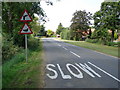
"Slow Down, Me Duck!"
Using the Lincolnshire vernacular maybe explains why the lower of the two warning signs before you enter Potterhanworth is duck-shaped, as locals tend to refer to each other as 'Duck'!
Image: © Ian Paterson
Taken: 10 Aug 2007
0.12 miles
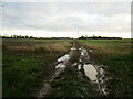
5
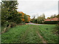
Demolished Transmission Mast and Old Road
The 1:50,000 scale "Get-a-Map" for this grid square shows a Transmitting Mast at this point, but it has long gone. Instead, here is what appears to be the 'old road' which puzzingly takes a more direct route between Nocton and Potterhanworth than the present road.
Image: © Ian Paterson
Taken: 10 Aug 2007
0.14 miles
7
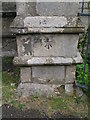
Cut bench mark, Potterhanworth St Andrew's church
Good condition cut bench mark on the west face of a buttress at the north-west angle of the church tower. It was levelled at 21.1836m above Ordnance datum in 1965. Recorded on Bench Marks database at http://www.bench-marks.org.uk/bm34510.
Image: © Brian Westlake
Taken: 20 May 2010
0.17 miles
8
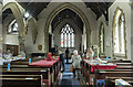
Interior, St Andrew's church, Potterhanworth
A cake sale was in progress.
Image: © Julian P Guffogg
Taken: 21 May 2022
0.17 miles
9
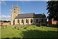
The Church of St Andrew, Potterhanworth
There is not much written up about this church other than to say it has 'a medieval tower, but the rest of the church was rebuilt 1856-7 to replace one of 1749'. The rest of the description refer to the inside, of which I did not visit.
It's just possible, through the trees, to see a former water tower that has been converted into a private house.
Image: © Dave Hitchborne
Taken: 26 Aug 2013
0.17 miles
10
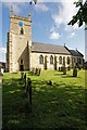
The Church of St Andrew, Potterhanworth
The clock, on the medieval tower, says 09:55. Unfortunately the Exif file for the photograph shows 08:55 having not been corrected for British Summertime.
The well kept churchyard shows off the church.
Image: © Dave Hitchborne
Taken: 26 Aug 2013
0.17 miles