IMAGES TAKEN NEAR TO
Park View Mews, LINCOLN, LN4 1PN
Introduction
This page details the photographs taken nearby to Park View Mews, LN4 1PN by members of the Geograph project.
The Geograph project started in 2005 with the aim of publishing, organising and preserving representative images for every square kilometre of Great Britain, Ireland and the Isle of Man.

There are currently over 7.5m images from over14,400 individuals and you can help contribute to the project by visiting https://www.geograph.org.uk
Image Map
Images are licensed for reuse under creativecommons.org/licenses/by-sa/2.0
Notes
- Clicking on the map will re-center to the selected point.
- The higher the marker number, the further away the image location is from the centre of the postcode.
Image Listing (8 Images Found)
Images are licensed for reuse under creativecommons.org/licenses/by-sa/2.0
Image
Details
Distance
2
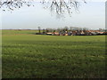
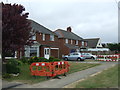
Town & Country
Many villages in Lincolnshire are expanding fast. Here new housing pushes Branston deeper into the fields.
Image: © Ian Carrington
Taken: 15 Dec 2005
0.21 miles
3
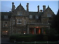
Branston Hall
Built in 1885, this stately home was converted to a hospital by the RAF during WWII. It was closed in the 80's and stood empty for some years before being reopened as a retirement home. It was finally converted into a posh hotel
Image: © Matthew Smith
Taken: 21 Sep 2005
0.22 miles
5
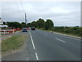
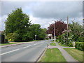
Lincoln Road (B1188), Branston
Heading west.
Image: © JThomas
Taken: 20 Jul 2013
0.23 miles
6
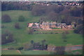
Branston Hall Hotel in Branston Park: aerial 2014
Image: © Chris
Taken: 9 Apr 2014
0.24 miles
7
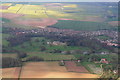
Branston: aerial 2014
Branston Hall Hotel and Branston Park in front.
Image: © Chris
Taken: 9 Apr 2014
0.24 miles
8
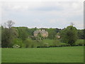
Branston Hall
Branston Hall and its surrounding grounds.
Image: © Matthew Smith
Taken: 9 May 2007
0.25 miles