IMAGES TAKEN NEAR TO
Cliff Lane, LINCOLN, LN4 1JY
Introduction
This page details the photographs taken nearby to Cliff Lane, LN4 1JY by members of the Geograph project.
The Geograph project started in 2005 with the aim of publishing, organising and preserving representative images for every square kilometre of Great Britain, Ireland and the Isle of Man.

There are currently over 7.5m images from over14,400 individuals and you can help contribute to the project by visiting https://www.geograph.org.uk
Image Map
Images are licensed for reuse under creativecommons.org/licenses/by-sa/2.0
Notes
- Clicking on the map will re-center to the selected point.
- The higher the marker number, the further away the image location is from the centre of the postcode.
Image Listing (14 Images Found)
Images are licensed for reuse under creativecommons.org/licenses/by-sa/2.0
Image
Details
Distance
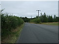
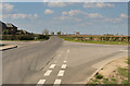
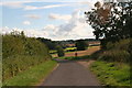
1
Cliff Lane
A No Through Road to Cliff Farm.
Image: © Julian P Guffogg
Taken: 30 Mar 2021
0.01 miles
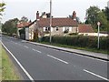
3
Crossroads near Washingborough
Heighington Road ahead, right is Church Hill towards Washingborough.
Image: © Julian P Guffogg
Taken: 30 Mar 2021
0.10 miles
5
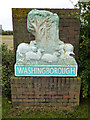
Washingborough village sign
Village sign at the junction of Heighington Lane and Church Hill http://www.geograph.org.uk/photo/2081074
Image: © Richard Croft
Taken: 24 Sep 2010
0.14 miles
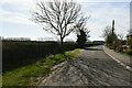
6
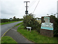
Church Hill
Entering Washingborough from Heighington Lane
Image: © Richard Croft
Taken: 24 Sep 2010
0.15 miles
7
Junction of Cliff Lane and Wellsykes Lane, Washingborough
Image: © Chris
Taken: 12 Sep 2015
0.16 miles
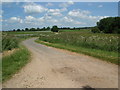
8
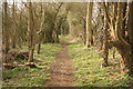
Wellsykes Lane
Ancient thoroughfare near Heighington
Image: © Richard Croft
Taken: 2 Mar 2012
0.20 miles