IMAGES TAKEN NEAR TO
Karglen Industrial Estate, The Moors, LINCOLN, LN4 1HY
Introduction
This page details the photographs taken nearby to Karglen Industrial Estate, The Moors, LN4 1HY by members of the Geograph project.
The Geograph project started in 2005 with the aim of publishing, organising and preserving representative images for every square kilometre of Great Britain, Ireland and the Isle of Man.

There are currently over 7.5m images from over14,400 individuals and you can help contribute to the project by visiting https://www.geograph.org.uk
Image Map (Loading...)


Getting Data...Please wait
Leaflet Map data © OpenStreetMap
Images are licensed for reuse under creativecommons.org/licenses/by-sa/2.0
Notes
- Clicking on the map will re-center to the selected point.
- The higher the marker number, the further away the image location is from the centre of the postcode.
Image Listing (7 Images Found)
Images are licensed for reuse under creativecommons.org/licenses/by-sa/2.0
Image
Details
Distance
2
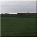
Diverted footpath
Part of the Spires and Steeples Trail.
This path used to cross the railway near Karglen Industrial Park but now is diverted alongside the railway.
Image: © Jonathan Thacker
Taken: 16 May 2019
0.16 miles
3

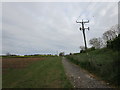
Country road near Branston (1)
The bridge ahead carries the railway between Lincoln (left) and Sleaford (right).
Image: © Stephen Richards
Taken: 15 Jun 2015
0.22 miles
4
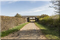
Railway bridge over Potterhanworth Road
Compare with Image
Image: © Julian P Guffogg
Taken: 30 Mar 2021
0.22 miles
5
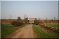
Rail Bridge
Rural rail bridge on Branston Moor
Image: © Richard Croft
Taken: 28 Mar 2007
0.22 miles
6
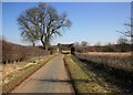
Lincoln - Sleaford line rail overbridge
Quiet country lane leading under the railway
Image: © roger geach
Taken: 7 Mar 2010
0.23 miles
7
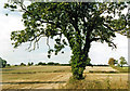
Tree, Branston Moor, by Potterhanworth Road
Image: © Jo and Steve Turner
Taken: 28 Oct 2001
0.23 miles