IMAGES TAKEN NEAR TO
Dunnock Close, LINCOLN, LN4 1FU
Introduction
This page details the photographs taken nearby to Dunnock Close, LN4 1FU by members of the Geograph project.
The Geograph project started in 2005 with the aim of publishing, organising and preserving representative images for every square kilometre of Great Britain, Ireland and the Isle of Man.

There are currently over 7.5m images from over14,400 individuals and you can help contribute to the project by visiting https://www.geograph.org.uk
Image Map
Images are licensed for reuse under creativecommons.org/licenses/by-sa/2.0
Notes
- Clicking on the map will re-center to the selected point.
- The higher the marker number, the further away the image location is from the centre of the postcode.
Image Listing (10 Images Found)
Images are licensed for reuse under creativecommons.org/licenses/by-sa/2.0
Image
Details
Distance
1
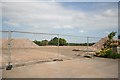
Former Moor Lodge Hotel
Formerly Image in the throes of new housing development.
Image: © Richard Croft
Taken: 5 Jun 2007
0.08 miles
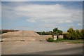
2

Moor Lodge Hotel
Closed, derelict and vandalised - destined for housing development.
Image: © Richard Croft
Taken: 5 Apr 2007
0.09 miles
3
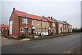
Lodge Gardens
New houses on the site of Branston Hotel http://www.geograph.org.uk/photo/393934
Image: © Richard Croft
Taken: 8 Dec 2008
0.09 miles
4

Moor Lodge Hotel
Former hotel, closed, derelict and vandalised .... recently sold for housing development
Image: © Richard Croft
Taken: 5 Apr 2007
0.09 miles
5
Former Moor Lodge Hotel
Demolished view of http://www.geograph.org.uk/photo/393940
Image: © Richard Croft
Taken: 5 Jun 2007
0.11 miles
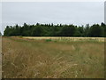
6
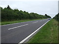
Sleafrod Road (B1188)
Towards Metheringham.
Image: © JThomas
Taken: 20 Jul 2013
0.12 miles
8
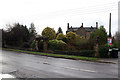
Stonefield House, 14 Sleaford Road, Branston
The early 19th century house and gates are Grade II Listed. The house was known locally as The Monkey House because of squat monkeys on the garden piers and is variously referred to as a Victorian folly. It was owned and built by Thomas Lovelee (1808-1877), a Corn Miller, Stonemason, and Lime Burner by trade. In 1904 the Forman family rented the house and attached buildings described as 'stable, blacksmiths shop, saw pit, woodworking shop, grainery, paddock, wells with plenty of water etc' that became the base for the Forman Bros Thrashing and Transport Contractors Branston Limited. The 1911 census records a Walter Richardson, aged 20 years, lodger at Stonefield House working as a thrashing machine feeder. The Forman family purchased the house in 1917-18. Pevsner in 1964 notes 'No-one should miss Mr Loveley’s gate piers at Branston'
Image: © Jo and Steve Turner
Taken: 28 Nov 2019
0.17 miles
10
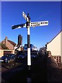
Old Direction Sign - Signpost by the B1188, High Street, Branston
Pawn finial - 4 arms; by the B1188, in parish of Branston and Mere (North Kesteven District), junction of High Street with Station Road, Branston, on verge, by stone wall.
Surveyed
Milestone Society National ID: LI_TF0267
Image: © Milestone Society
Taken: Unknown
0.25 miles