IMAGES TAKEN NEAR TO
Pynder Close, LINCOLN, LN4 1EX
Introduction
This page details the photographs taken nearby to Pynder Close, LN4 1EX by members of the Geograph project.
The Geograph project started in 2005 with the aim of publishing, organising and preserving representative images for every square kilometre of Great Britain, Ireland and the Isle of Man.

There are currently over 7.5m images from over14,400 individuals and you can help contribute to the project by visiting https://www.geograph.org.uk
Image Map
Images are licensed for reuse under creativecommons.org/licenses/by-sa/2.0
Notes
- Clicking on the map will re-center to the selected point.
- The higher the marker number, the further away the image location is from the centre of the postcode.
Image Listing (9 Images Found)
Images are licensed for reuse under creativecommons.org/licenses/by-sa/2.0
Image
Details
Distance
1
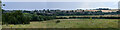
Washingborough Panorama
Taken from near Greetwell church.
Image: © Julian P Guffogg
Taken: 3 Aug 2021
0.13 miles
2
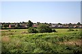
Washingborough
View from the old station
Image: © Richard Croft
Taken: 5 Aug 2007
0.17 miles
3
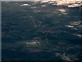
Washingborough and RAF Waddington from the air
Washingborough is in the foreground, by the River Witham. RAF Waddington https://en.wikipedia.org/wiki/RAF_Waddington can be seen in the distance.
Image: © Thomas Nugent
Taken: 19 Oct 2018
0.18 miles
4
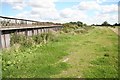
Old railway bridge over the South Delph
View east along the South Delph bank near Washingborough
Image: © Richard Croft
Taken: 23 Aug 2008
0.23 miles
5
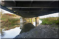
Under the old railway bridge
The line closed years ago, but the bridge is still in relatively good condition. It originally carried the Great Northern Railway over the South Delph.
Image: © Julian P Guffogg
Taken: 10 Nov 2021
0.24 miles
6

Old railway bridge
The line closed years ago, but the bridge is still in relatively good condition. It originally carried the Great Northern Railway over the South Delph.
Image: © Julian P Guffogg
Taken: 10 Nov 2021
0.24 miles
7

River Witham and South Delph at Washingborough: aerial 2015
For a close-up of the disused railway bridge in the centre see Image
Image: © Chris
Taken: 7 Sep 2015
0.24 miles
8

River Witham and South Delph at Washingborough: aerial 2015
Disused railway bridge over South Delph, where this branch line joined the L. and N.E.R. Line running along the Witham bank - see Historic Map on Submit page of this site and Image
Image: © Chris
Taken: 7 Sep 2015
0.24 miles
9
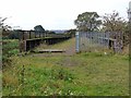
Old railway bridge over the South Delph
A railway (closed 1963) formerly followed the floodbank of the River Witham from Boston to Lincoln. At this point, only 3 km west of Lincoln, it diverged from the river, crossing the South Delph to enter the southern part of Lincoln.
Image: © Oliver Dixon
Taken: 11 Oct 2012
0.25 miles