IMAGES TAKEN NEAR TO
Oak Hill, LINCOLN, LN4 1BA
Introduction
This page details the photographs taken nearby to Oak Hill, LN4 1BA by members of the Geograph project.
The Geograph project started in 2005 with the aim of publishing, organising and preserving representative images for every square kilometre of Great Britain, Ireland and the Isle of Man.

There are currently over 7.5m images from over14,400 individuals and you can help contribute to the project by visiting https://www.geograph.org.uk
Image Map (Loading...)


Getting Data...Please wait
Leaflet Map data © OpenStreetMap
Images are licensed for reuse under creativecommons.org/licenses/by-sa/2.0
Notes
- Clicking on the map will re-center to the selected point.
- The higher the marker number, the further away the image location is from the centre of the postcode.
Image Listing (49 Images Found)
Images are licensed for reuse under creativecommons.org/licenses/by-sa/2.0
Image
Details
Distance
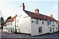
1
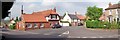
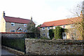
Washingborough village
The junction of Oak Hill and High Street in the village of Washingborough, Lincolnshire. The public house is 'The Hunter's Leap'.
Image: © Len Williams
Taken: 21 Jun 2013
0.04 miles
2
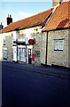
5 and 7 High Street Washingborough
Grade II Listed and formerly 3 late 18th century cottages that became two houses and post office and reverted back to two homes again in 2006. See it after conversion back to a house here in 2012 Image Number 9, just in picture on the right, is also Grade II Listed but early 18th century.
Image: © Jo and Steve Turner
Taken: Unknown
0.04 miles
3
5 and 7 High Street, Washingborough
Grade II Listed and formerly 3 late 18th century cottages that became two houses and post office and reverted back to two homes again in 2006. See it still a post office here in 2000 Image
Image: © Jo and Steve Turner
Taken: 26 Feb 2012
0.04 miles
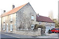
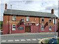
5
Ferry Boat Inn, High Street, Washingborough
Grade II Listed early 18th century inn with later alterations and additions. Reportedly built in 1625 and so named as the landlord ran the ferry across the River Witham. It is claimed that this is because the River Witham ran at the bottom of the street along the course of Main Road at the time. However, although inconclusive LiDAR evidence does not support this. In addition an auger survey we carried out with James Rackham as part of the Witham Valley project places the Roman Car Dyke alongside the Main Road (as indicated on the OS maps) making the river adopting a course that close to the inn extremely unlikely without removing evidence of the dyke. The 'George and Dragon' mounted above the hanging sign is the livery of defunct brewery of Mann, Crossman & Paulin of London and Burton-upon-Trent.
Image: © Jo and Steve Turner
Taken: 26 Feb 2012
0.05 miles
6
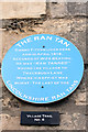
Plaque on 59 Main Road, Washingborough
Image: © Jo and Steve Turner
Taken: 26 Feb 2012
0.06 miles
8
Washingborough village
The entrance to St John the Evangelist Church at Washingborough, Lincolnshire. The church can be seen on the left of the picture.
Image: © Len Williams
Taken: 21 Jun 2013
0.06 miles
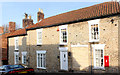
9
Church House 14 and Cornerstone 10 High Street, Washingborough
Both Grade II Listed, Church House (left) is 1883 and Cornerstone, formerly a house with attached cottage, is early 19th century.
Image: © Jo and Steve Turner
Taken: 26 Feb 2012
0.06 miles
10
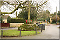
Village Cross
Grade II listed and Scheduled Ancient Monument, 15th century cross base and shaft restored in 1903
Image: © Richard Croft
Taken: 5 Jan 2013
0.06 miles