IMAGES TAKEN NEAR TO
Fen Road, LINCOLN, LN4 1AE
Introduction
This page details the photographs taken nearby to Fen Road, LN4 1AE by members of the Geograph project.
The Geograph project started in 2005 with the aim of publishing, organising and preserving representative images for every square kilometre of Great Britain, Ireland and the Isle of Man.

There are currently over 7.5m images from over14,400 individuals and you can help contribute to the project by visiting https://www.geograph.org.uk
Image Map
Images are licensed for reuse under creativecommons.org/licenses/by-sa/2.0
Notes
- Clicking on the map will re-center to the selected point.
- The higher the marker number, the further away the image location is from the centre of the postcode.
Image Listing (8 Images Found)
Images are licensed for reuse under creativecommons.org/licenses/by-sa/2.0
Image
Details
Distance
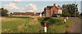
3
Washingborough
Looking northwest from Foster's Bridge
Image: © Ian Carrington
Taken: 24 Jan 2006
0.09 miles
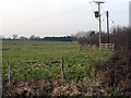
4
Footpath to the Withern from the B1190 near Foster's Bridge
Image: © Chris
Taken: 12 Sep 2015
0.17 miles
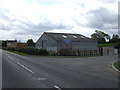
6
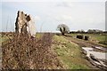
North Dales Road
Track known as North Dales Road on Washingborough Fen near Sandhill Beck.
Image: © Richard Croft
Taken: Unknown
0.22 miles
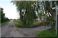
7
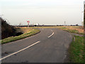
Foster's Bridge
Looking north from Fen Road
Image: © Ian Carrington
Taken: 24 Jan 2006
0.23 miles
8
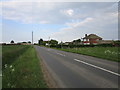
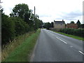
Heighington Fen
A straggle of houses along the B1190.
Image: © Jonathan Thacker
Taken: 20 May 2019
0.24 miles