IMAGES TAKEN NEAR TO
Westfield Road, LINCOLN, LN3 5TE
Introduction
This page details the photographs taken nearby to Westfield Road, LN3 5TE by members of the Geograph project.
The Geograph project started in 2005 with the aim of publishing, organising and preserving representative images for every square kilometre of Great Britain, Ireland and the Isle of Man.

There are currently over 7.5m images from over14,400 individuals and you can help contribute to the project by visiting https://www.geograph.org.uk
Image Map
Images are licensed for reuse under creativecommons.org/licenses/by-sa/2.0
Notes
- Clicking on the map will re-center to the selected point.
- The higher the marker number, the further away the image location is from the centre of the postcode.
Image Listing (11 Images Found)
Images are licensed for reuse under creativecommons.org/licenses/by-sa/2.0
Image
Details
Distance

2
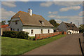
Cottage in Southrey
With an attractive thatched roof
Image: © Andy Stephenson
Taken: 29 Dec 2015
0.06 miles
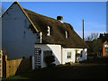
3
Mud & stud cottages
Two 17th century mud & stud cottages on High Thorpe in Southrey. The nearest one, Sudtrie Cottage, has been brick-skinned and roofed over the thatch, Cuckoo Bush Cottage is still thatched and may have originally been two houses.
Image: © Richard Croft
Taken: 3 May 2014
0.07 miles
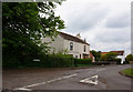
4
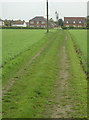
Bridleway at Southrey
The buildings form the 'Highthorpe' part of the village, which is at least 2 metres higher than the 'Lowthorpe'
Image: © Alan Murray-Rust
Taken: 13 May 2007
0.07 miles
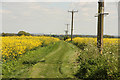
5

Ferry Road
National Cycle Route 1 heading north from Southrey.
Image: © JThomas
Taken: 17 Jul 2020
0.08 miles
7
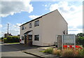
House on Ferry Road, Southrey
Showing position of Postbox No. LN3 185.
See Image] for postbox.
Image: © JThomas
Taken: 17 Jul 2020
0.14 miles
8
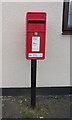
Elizabeth II postbox on Ferry Road, Southrey
Postbox No. LN3 185.
See Image] for context.
Image: © JThomas
Taken: 17 Jul 2020
0.14 miles
9
The Viking Way
The Viking Way east from Ferry Road on a bridleway towards Abbey Warren Farm
Image: © Richard Croft
Taken: 3 May 2014
0.15 miles