IMAGES TAKEN NEAR TO
LN3 5LE
Introduction
This page details the photographs taken nearby to LN3 5LE by members of the Geograph project.
The Geograph project started in 2005 with the aim of publishing, organising and preserving representative images for every square kilometre of Great Britain, Ireland and the Isle of Man.

There are currently over 7.5m images from over14,400 individuals and you can help contribute to the project by visiting https://www.geograph.org.uk
Image Map
Images are licensed for reuse under creativecommons.org/licenses/by-sa/2.0
Notes
- Clicking on the map will re-center to the selected point.
- The higher the marker number, the further away the image location is from the centre of the postcode.
Image Listing (6 Images Found)
Images are licensed for reuse under creativecommons.org/licenses/by-sa/2.0
Image
Details
Distance
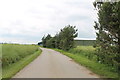
1
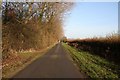
The road to West Torrington
Looking north near Freshfield Farm
Image: © Richard Croft
Taken: 19 Nov 2008
0.04 miles
2
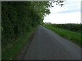
Minor road towards West Torrington
Heading north.
Image: © JThomas
Taken: 15 Jun 2015
0.12 miles
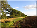
6
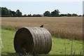
Hunting ground
A kestrel perches on a hay bale surveying a cornfield for likely prey
Image: © Richard Croft
Taken: 3 Aug 2009
0.21 miles