IMAGES TAKEN NEAR TO
Lindum Terrace, LINCOLN, LN2 5RP
Introduction
This page details the photographs taken nearby to Lindum Terrace, LN2 5RP by members of the Geograph project.
The Geograph project started in 2005 with the aim of publishing, organising and preserving representative images for every square kilometre of Great Britain, Ireland and the Isle of Man.

There are currently over 7.5m images from over14,400 individuals and you can help contribute to the project by visiting https://www.geograph.org.uk
Image Map (Loading...)


Getting Data...Please wait
Leaflet Map data © OpenStreetMap
Images are licensed for reuse under creativecommons.org/licenses/by-sa/2.0
Notes
- Clicking on the map will re-center to the selected point.
- The higher the marker number, the further away the image location is from the centre of the postcode.
Image Listing (611 Images Found)
Images are licensed for reuse under creativecommons.org/licenses/by-sa/2.0
Image
Details
Distance
1
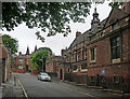
School, Upper Lindum Street, Lincoln
The former Lincoln Grammar School (now Lincoln Minster School) by William Watkins, 1884. The headmaster's house can be seen beyond.
Image: © Stephen Richards
Taken: 14 Jun 2015
0.04 miles
2
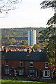
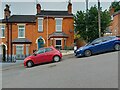
52 to 58 Lindum Avenue, Lincoln and Shuttleworth House, Stamp End from Lindum Terrace
52 to 62 are six houses built by the Lincoln Land and Building Society (58-62 built sometime in or after 1913). Architects Goddard and Son had proposed the street layout in 1878 with terrace housing on the south side. The road wasn’t tarmacked until the 1990s. Incongruously poking 44m into the sky in the distance is Shuttleworth House, a 17-storey apartment block opened on 17th March 1966, containing 81 one- and 49 two-bedroom flats. It was Built by Truscon Limited and was the latest trend in modern architecture at the time. It was re-opened on 19th May 2016 after a £3.2m refurbishment to provide tenants with greener and cleaner energy. (Joseph Shuttleworth (1819-1883) and his brother-in-law partner Nathaniel Clayton (1811–1890) had a significant economic impact on Lincoln and its development as an engineering powerhouse.)
Image: © Jo and Steve Turner
Taken: 12 Nov 2005
0.08 miles
3
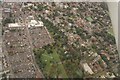
Lincoln from the Arboretum to the Cathedral: aerial 2021
Image: © Chris
Taken: 16 Oct 2021
0.09 miles
4
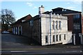
Lindum Road
Stabling at the Adam & Eve http://www.geograph.org.uk/photo/654619 and house with a 19th century front on Lindum Road near Pottergate
Image: © Richard Croft
Taken: 6 Jan 2008
0.09 miles
5
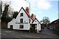
The Adam & Eve
Historic and popular hostelry in Lincoln near Pottergate, it was threatened with closure several years ago but the developer's plans were thwarted by a vociferous local campaign to save it
Image: © Richard Croft
Taken: 5 Jan 2008
0.09 miles
6
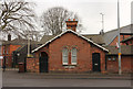
The Lodge
Former Lodge to The Mount on Wragby Road, now part of the Minster School
Image: © Richard Croft
Taken: 14 Feb 2015
0.09 miles
9

Upper Lindum Street
Buildings belonging to Lincoln Minster School are on both sides of this street.
Image: © Bill Boaden
Taken: 14 Jul 2024
0.10 miles
10
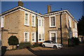
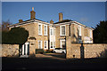
Lindum House
Grade II listed house c1840 on Sewell Road
Image: © Richard Croft
Taken: 15 Nov 2011
0.10 miles