IMAGES TAKEN NEAR TO
Upper Lindum Street, LINCOLN, LN2 5RN
Introduction
This page details the photographs taken nearby to Upper Lindum Street, LN2 5RN by members of the Geograph project.
The Geograph project started in 2005 with the aim of publishing, organising and preserving representative images for every square kilometre of Great Britain, Ireland and the Isle of Man.

There are currently over 7.5m images from over14,400 individuals and you can help contribute to the project by visiting https://www.geograph.org.uk
Image Map
Images are licensed for reuse under creativecommons.org/licenses/by-sa/2.0
Notes
- Clicking on the map will re-center to the selected point.
- The higher the marker number, the further away the image location is from the centre of the postcode.
Image Listing (1582 Images Found)
Images are licensed for reuse under creativecommons.org/licenses/by-sa/2.0
Image
Details
Distance
1
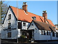
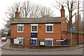
The Adam & Eve
Historic and popular hostelry in Lincoln near Pottergate, it was threatened with closure several years ago but the developer's plans were thwarted by a vociferous local campaign to save it
Image: © Richard Croft
Taken: 5 Jan 2008
0.02 miles
2
Lindum Road
Stabling at the Adam & Eve http://www.geograph.org.uk/photo/654619 and house with a 19th century front on Lindum Road near Pottergate
Image: © Richard Croft
Taken: 6 Jan 2008
0.03 miles
3
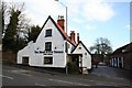
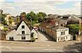
School, Upper Lindum Street, Lincoln
The former Lincoln Grammar School (now Lincoln Minster School) by William Watkins, 1884. The headmaster's house can be seen beyond.
Image: © Stephen Richards
Taken: 14 Jun 2015
0.03 miles
4
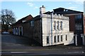
Upper Lindum Street
Buildings belonging to Lincoln Minster School are on both sides of this street.
Image: © Bill Boaden
Taken: 14 Jul 2024
0.03 miles
6
The Adam and Eve Tavern
The Adam & Eve is reputedly the oldest Tavern in Lincoln dating back as far as the late seventeenth century and is a well known city landmark in the shadow of the Cathedral (http://adamandevelincoln.co.uk/ - Adam and Eve website).
It stands on Lindum Hill opposite the mediæval Image It is a grade II listed building (English Heritage Building ID: 486071 http://www.britishlistedbuildings.co.uk/en-486071-adam-and-eve-public-house-lincolnshire British Listed Buildings).
Image: © David Dixon
Taken: 5 Aug 2014
0.06 miles
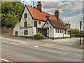
7
The Lodge
Former Lodge to The Mount on Wragby Road, now part of the Minster School
Image: © Richard Croft
Taken: 14 Feb 2015
0.06 miles
8
View from Pottergate Arch
View from the roof of Pottergate Arch https://www.geograph.org.uk/photo/3711454 to The Adam & Eve https://www.geograph.org.uk/photo/108483 and Lindum Holme Lodge https://www.geograph.org.uk/photo/2747471 on Lindum Road
Image: © Richard Croft
Taken: 9 Aug 2023
0.06 miles
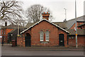
9
Winnowsty Cottage
Grade II listed, early 19th century former house on Wragby Road, now part of the Minster School
Image: © Richard Croft
Taken: 14 Feb 2015
0.06 miles
10
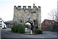
Pottergate Arch
Pottergate is the name of the road, derived from the Danish 'gata' (Street) of the potters. The arch is the 14th century gatehouse to the Cathedral Close, seen here looking south from Pottergate towards Lindum Road
Image: © Richard Croft
Taken: 5 Jan 2008
0.06 miles