IMAGES TAKEN NEAR TO
Horton Street, LINCOLN, LN2 5NG
Introduction
This page details the photographs taken nearby to Horton Street, LN2 5NG by members of the Geograph project.
The Geograph project started in 2005 with the aim of publishing, organising and preserving representative images for every square kilometre of Great Britain, Ireland and the Isle of Man.

There are currently over 7.5m images from over14,400 individuals and you can help contribute to the project by visiting https://www.geograph.org.uk
Image Map
Images are licensed for reuse under creativecommons.org/licenses/by-sa/2.0
Notes
- Clicking on the map will re-center to the selected point.
- The higher the marker number, the further away the image location is from the centre of the postcode.
Image Listing (124 Images Found)
Images are licensed for reuse under creativecommons.org/licenses/by-sa/2.0
Image
Details
Distance
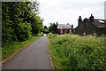
5
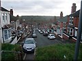
Horton Street, Lincoln
View south from the track carrying the Viking Way along the north escarpment
Image: © Tim Heaton
Taken: 3 Dec 2011
0.05 miles

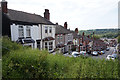
7
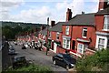
The sunny side of the street
The west side of Laceby Road
Image: © Richard Croft
Taken: 21 Jun 2007
0.06 miles
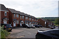
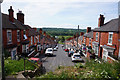
9

Monks Road Methodist Church
Opened in 1962
Image: © Wendy Parkinson
Taken: 3 Sep 2000
0.08 miles
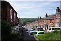
10
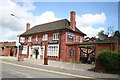
Manvers Arms
Recently closed and up for sale pub on Monks Road
Image: © Richard Croft
Taken: 21 Jun 2007
0.10 miles