IMAGES TAKEN NEAR TO
Bentinck Square, LINCOLN, LN2 5EA
Introduction
This page details the photographs taken nearby to Bentinck Square, LN2 5EA by members of the Geograph project.
The Geograph project started in 2005 with the aim of publishing, organising and preserving representative images for every square kilometre of Great Britain, Ireland and the Isle of Man.

There are currently over 7.5m images from over14,400 individuals and you can help contribute to the project by visiting https://www.geograph.org.uk
Image Map
Images are licensed for reuse under creativecommons.org/licenses/by-sa/2.0
Notes
- Clicking on the map will re-center to the selected point.
- The higher the marker number, the further away the image location is from the centre of the postcode.
Image Listing (189 Images Found)
Images are licensed for reuse under creativecommons.org/licenses/by-sa/2.0
Image
Details
Distance
1
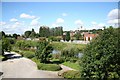
Lincoln View
View from the viewing platform http://www.geograph.org.uk/photo/933959 at the start of the Water Rail Way
Image: © Richard Croft
Taken: 23 Aug 2008
0.06 miles
2
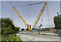
Giant Crane
A huge Liebherr 1,200 tonne capacity mobile crane with a 107 metre long jib in use at the Stamp End railway bridge which is being replaced.
Image: © Julian P Guffogg
Taken: 6 Aug 2017
0.08 miles
3

Cromwell Street
Late 19th century terraced houses built by J.Mills & Co. Unusually for the area, with three storeys, though built on a smaller footprint than surrounding streets.
Image: © Richard Croft
Taken: 27 Mar 2023
0.08 miles
4

Houses between Monks Road and the railway, Lincoln: aerial 2016
NE of Stamp End.
Image: © Chris
Taken: 24 Jun 2016
0.08 miles
5
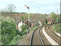
Leaving Lincoln
The terraced houses on the hillside are masked by line side vegetation as the rail line approaches Spa Street, Lincoln
Image: © Donnylad
Taken: 25 Apr 2006
0.08 miles
6

Spa Road Power Station
Taken not long before it was demolished this electricity generating station at Spa Road was built between 1945 and 1948 with northern extension of 1953. It replaced the Clayton and Shuttleworth station on the same site, purchased by the City Council in 1917. Little seems to be known of the original power plant on this site but the architects for this building were Mouchel and Partners and the estimated cost was £1,448,516. The 60MW station was then nationalised in 1948 under the Central Electricity Generating Board. Generating plant was decommissioned in 1984 with the closed site then becoming overgrown and falling into decay. The main buildings were demolished in 2003. The land has more recently largely been cleared of trees and shrubbery and outline planning shows a proposed new, over 300 home, housing estate. Unfortunately, there seem to be few structures surviving from Lincoln's early electricity system, although there are reportedly sub-stations on the corners of Newport and Church Lane (Image) and Monks Road, in the corner of the arboretum. Power to the sub-stations built in the 1930s was probably fed from the Clayton and Shuttleworth power station and later this Spa Road Power Station. There is also a sub-station on the corner of Cross Street and Thesiger Street with very similar design (Image).
Image: © Jo and Steve Turner
Taken: Unknown
0.09 miles
7
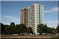
Shuttleworth House
Tower block in the lower city at Stamp End
Image: © Richard Croft
Taken: 11 Aug 2010
0.10 miles
8
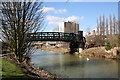
Stamp End Bridge
The last road bridge over the River Witham in Lincoln
Image: © Richard Croft
Taken: 2 Mar 2006
0.10 miles
9
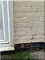
Cut Mark: Lincoln, 54A Winn Street
Cut bench mark to the right of the doorway. See https://www.geograph.org.uk/photo/6857444 for a wider view and https://www.bench-marks.org.uk/bm148594 for details of the mark.
Image: © Brian Westlake
Taken: 3 Jun 2021
0.10 miles
10

House on the corner of Winn Street and Oakfield Street
There is a cut bench mark to the right of the doorway to 54A, the farther door. See https://www.geograph.org.uk/photo/6857439 for a closer view and https://www.bench-marks.org.uk/bm148594 for details of the mark.
Image: © Brian Westlake
Taken: 3 Jun 2021
0.10 miles