IMAGES TAKEN NEAR TO
Friars Lane, LINCOLN, LN2 5AL
Introduction
This page details the photographs taken nearby to Friars Lane, LN2 5AL by members of the Geograph project.
The Geograph project started in 2005 with the aim of publishing, organising and preserving representative images for every square kilometre of Great Britain, Ireland and the Isle of Man.

There are currently over 7.5m images from over14,400 individuals and you can help contribute to the project by visiting https://www.geograph.org.uk
Image Map
Images are licensed for reuse under creativecommons.org/licenses/by-sa/2.0
Notes
- Clicking on the map will re-center to the selected point.
- The higher the marker number, the further away the image location is from the centre of the postcode.
Image Listing (1424 Images Found)
Images are licensed for reuse under creativecommons.org/licenses/by-sa/2.0
Image
Details
Distance
1
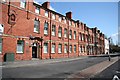
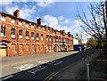
Unity Square
Former Oddfellows Hall in Unity Square off Broadgate, now student accommodation
Image: © Richard Croft
Taken: 17 Apr 2008
0.02 miles
2
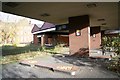
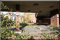
Broadgate Service Station
Long-disused service station on Broadgate, destined for redevelopment
Image: © Richard Croft
Taken: 18 Nov 2008
0.02 miles
3
Broadgate Service Station
Long-disused service station on Broadgate, destined for redevelopment
Image: © Richard Croft
Taken: 18 Nov 2008
0.02 miles
4
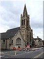
St Hugh, Lincoln
This Catholic church was erected in 1893 in place of the former chapel of St John, in Silver Street. Bishop Bagshawe laid the foundation on the 17 November 1892. Thirteen months later on Tuesday 19 December 1893 the church was opened by Cardinal Vaughan and dedicated to St Hugh of Lincoln at a cost of £7300 including the benches and high altar. It seats 400 people. The church appears to be very popular with the Polish community.
Normally traffic would be nose to tail at 12:40pm on a Friday afternoon, but as can be seen, road works are in progress. The church is at the junction of Monk's Road, Broadgate and Silver Street.
The Saint Hugh was born in Avalon in 1140. He rebuilt the Cathedral of Lincoln, which was earthquake damaged, all but the west front. On his death he was buried close to the high altar. King John helped to carry the coffin up "The Steep" to the cathedral and he, with the King of Scotland, several archbishops, 14 bishops and 100 abbots, attended the funeral.
Image: © Dave Hitchborne
Taken: 6 Jul 2007
0.03 miles
5
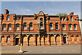
Former Oddfellows Hall, Unity Square
Built in 1879 by James Weighell and designed by architect W Mortimer. Over the years the Hall has been used as a meeting room, entertainment venue, Church of Christ, The Ruston Club and student accommodation. It now appears to be earmarked for demolition.
Image: © Gerald England
Taken: 13 Apr 2019
0.03 miles
6
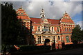
City School, Monks Road
Originally the City School on Monks Road, by George Sedger 1885-6 in the Dutch Reaniassance style. Now part of Lincoln College.
Image: © Richard Croft
Taken: 28 Feb 2006
0.03 miles
7
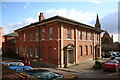
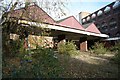
The Sessions House
A plain, brick, Georgian building by William Hayward in 1805 which served as the Sessions House with a gaol to the rear. It later became the Magistrates court and the gaol became the city police station until the new 'Ryvita House' http://www.geograph.org.uk/photo/108443 was built in 1970. Now part of the Lincoln College.
Image: © Richard Croft
Taken: 28 Feb 2006
0.03 miles
8
Broadgate Service Station
Long-disused service station on Broadgate, destined for redevelopment
Image: © Richard Croft
Taken: 18 Nov 2008
0.03 miles
9
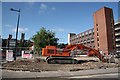
Broadgate demolition
Demolition of the former O'Rourke's pub http://www.geograph.org.uk/photo/763296 and Broadgate Service Station http://www.geograph.org.uk/photo/1059602
Image: © Richard Croft
Taken: 24 Jun 2009
0.03 miles
10
Oddfellows Hall
Former Oddfellows Hall in Unity Square, built in 1878, it was for many years Ruston's Club and latterly student accommodation. It is currently empty and for sale for £500,000 with planning permission for conversion to a 23-bedroom hotel.
Image: © Richard Croft
Taken: 11 Jun 2015
0.03 miles