IMAGES TAKEN NEAR TO
Lilford Road, LINCOLN, LN2 4TP
Introduction
This page details the photographs taken nearby to Lilford Road, LN2 4TP by members of the Geograph project.
The Geograph project started in 2005 with the aim of publishing, organising and preserving representative images for every square kilometre of Great Britain, Ireland and the Isle of Man.

There are currently over 7.5m images from over14,400 individuals and you can help contribute to the project by visiting https://www.geograph.org.uk
Image Map
Images are licensed for reuse under creativecommons.org/licenses/by-sa/2.0
Notes
- Clicking on the map will re-center to the selected point.
- The higher the marker number, the further away the image location is from the centre of the postcode.
Image Listing (19 Images Found)
Images are licensed for reuse under creativecommons.org/licenses/by-sa/2.0
Image
Details
Distance
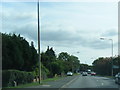
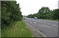
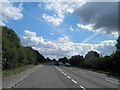
2
Bunkers Hill (A15)
Heading south west into Lincoln on the Old Roman Road.
Image: © JThomas
Taken: 6 Sep 2014
0.12 miles
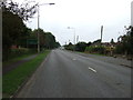
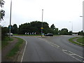
6
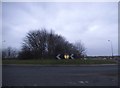
Roundabout on Bunkers Hill, Lincoln
In a couple of years there will be a new eastern bypass avoiding all the nonsense literally going round the houses heading north.
Image: © David Howard
Taken: 13 Jan 2018
0.18 miles
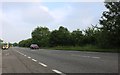
7
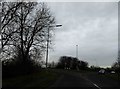
Roundabout ahead on Bunkers Hill A15 Lincoln
Image: © Steve Fareham
Taken: 8 Jan 2016
0.18 miles
8
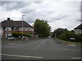
South end Hawthorn Chase, Glebe Park
Off Hawthorn Lane.
Image: © Richard Vince
Taken: 16 Jun 2018
0.18 miles
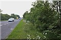
10
Roundabout on Wragby Road East (A158)
Old Roman Road into Lincoln.
Image: © JThomas
Taken: 6 Sep 2014
0.22 miles