IMAGES TAKEN NEAR TO
Wragby Road East, LINCOLN, LN2 4QY
Introduction
This page details the photographs taken nearby to Wragby Road East, LN2 4QY by members of the Geograph project.
The Geograph project started in 2005 with the aim of publishing, organising and preserving representative images for every square kilometre of Great Britain, Ireland and the Isle of Man.

There are currently over 7.5m images from over14,400 individuals and you can help contribute to the project by visiting https://www.geograph.org.uk
Image Map (Loading...)


Getting Data...Please wait
Leaflet Map data © OpenStreetMap
Images are licensed for reuse under creativecommons.org/licenses/by-sa/2.0
Notes
- Clicking on the map will re-center to the selected point.
- The higher the marker number, the further away the image location is from the centre of the postcode.
Image Listing (8 Images Found)
Images are licensed for reuse under creativecommons.org/licenses/by-sa/2.0
Image
Details
Distance
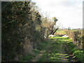
5
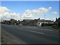
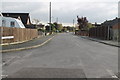
Wragby Road, North Greetwell
North Greetwell in a 1930s ribbon development expanded in the 1960s.
Image: © Jonathan Thacker
Taken: 25 Mar 2021
0.17 miles
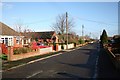
6
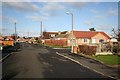
Westfield Avenue
Westfield Avenue in desirable North Greetwell
Image: © Richard Croft
Taken: 22 Jan 2007
0.19 miles
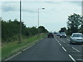
7
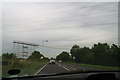
The Greatest Show on Earth? Working on the powerlines over the A158 near North Greetwell.
There seems to be suggestion of an aerial act, or perhaps a fine display of fireworks?
Or maybe it's a trampoline?
Image: © Chris
Taken: 1 Sep 2012
0.22 miles