IMAGES TAKEN NEAR TO
Bunkers Hill, LINCOLN, LN2 4QR
Introduction
This page details the photographs taken nearby to Bunkers Hill, LN2 4QR by members of the Geograph project.
The Geograph project started in 2005 with the aim of publishing, organising and preserving representative images for every square kilometre of Great Britain, Ireland and the Isle of Man.

There are currently over 7.5m images from over14,400 individuals and you can help contribute to the project by visiting https://www.geograph.org.uk
Image Map (Loading...)


Getting Data...Please wait
Leaflet Map data © OpenStreetMap
Images are licensed for reuse under creativecommons.org/licenses/by-sa/2.0
Notes
- Clicking on the map will re-center to the selected point.
- The higher the marker number, the further away the image location is from the centre of the postcode.
Image Listing (14 Images Found)
Images are licensed for reuse under creativecommons.org/licenses/by-sa/2.0
Image
Details
Distance
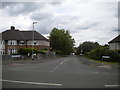
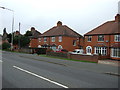
2
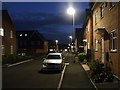
Kirkstall Close, Lincoln
Not on the map yet, but you'll find it here. http://www.houseprices.co.uk/map.php?pc=LN2+4GN&show=s
Photographed at 19:38hrs with the camera pinned up against a house wall.
Image: © Dave Hitchborne
Taken: 25 Sep 2007
0.10 miles
4
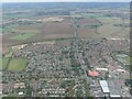
Lincoln NE: aerial 2021
Bunkers Hill and A158.
Image: © Simon Tomson
Taken: 16 Oct 2021
0.14 miles
5
South end Hawthorn Chase, Glebe Park
Off Hawthorn Lane.
Image: © Richard Vince
Taken: 16 Jun 2018
0.16 miles
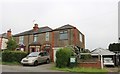
6
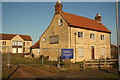
The Harvest Moon
Grade II listed, 18th century farmhouse and later pub on Wolsey Way. Glebe Farm disappeared as Glebe Park housing development through the 1980s & '90s, and the farmhouse became the Harvest Moon pub until November 2003. Derelict and vandalised, it's now for sale again.
Image: © Richard Croft
Taken: 3 Feb 2012
0.16 miles
7
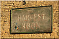
The sign of The Harvest Moon
Fading pub sign on the long-disused Harvest Moon http://www.geograph.org.uk/photo/2791213
Image: © Richard Croft
Taken: 3 Feb 2012
0.16 miles
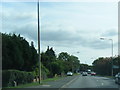
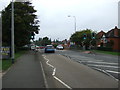
10
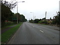
Bunkers Hill (A15)
Heading south west into Lincoln on the Old Roman Road.
Image: © JThomas
Taken: 6 Sep 2014
0.22 miles