IMAGES TAKEN NEAR TO
St. Giles Avenue, LINCOLN, LN2 4PE
Introduction
This page details the photographs taken nearby to St. Giles Avenue, LN2 4PE by members of the Geograph project.
The Geograph project started in 2005 with the aim of publishing, organising and preserving representative images for every square kilometre of Great Britain, Ireland and the Isle of Man.

There are currently over 7.5m images from over14,400 individuals and you can help contribute to the project by visiting https://www.geograph.org.uk
Image Map
Images are licensed for reuse under creativecommons.org/licenses/by-sa/2.0
Notes
- Clicking on the map will re-center to the selected point.
- The higher the marker number, the further away the image location is from the centre of the postcode.
Image Listing (206 Images Found)
Images are licensed for reuse under creativecommons.org/licenses/by-sa/2.0
Image
Details
Distance
1
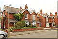
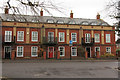
9-12 St Giles Avenue
Four of a delightful group of eight houses on St Giles Avenue, by J. H. Cooper for Joseph Ruston in 1896. When first built they cost about £250 each .... number 10 is currently for sale at £595,000 (July 2022).
Image: © Richard Croft
Taken: 15 Jul 2022
0.01 miles
3
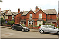
5-8 St Giles Avenue
Four of a delightful group of eight houses on St Giles Avenue, by J. H. Cooper for Joseph Ruston in 1896. When first built they cost about £250 each .... number 6 is currently for sale at £340,000 (July 2022).
Image: © Richard Croft
Taken: 15 Jul 2022
0.02 miles
4
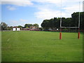
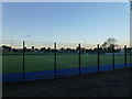
Lindum Sports Association
Sports ground changing and social club for Lincoln rugby club at the end of St Giles Avenue.
Image: © Michael Trolove
Taken: 12 Oct 2008
0.04 miles
5
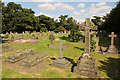
St.Peter-in-Eastgate cemetery
Long redundant cemetery for St.Peter-in-Eastgate and St.Mary's, formed in 1856 with 1 acre for St.Peter's and 1½ acres for St.Mary's. Hidden away behind houses on Langworthgate but marvellously maintained by Lincoln City Council.
Image: © Richard Croft
Taken: 15 Aug 2016
0.05 miles
6
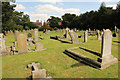
St.Peter-in-Eastgate cemetery
Long redundant cemetery for St.Peter-in-Eastgate and St.Mary's, formed in 1856 with 1 acre for St.Peter's and 1½ acres for St.Mary's. Hidden away behind houses on Langworthgate but marvellously maintained by Lincoln City Council.
Image: © Richard Croft
Taken: 15 Aug 2016
0.05 miles
8
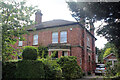
3 The Grove, Lincoln
No. 3 is half of what it was, 3 and 4 being built as one detached house (Grove House) and subsequently subdivided. It was built to an application in 1876 for W Sims, builder, architects Goddard and Son. H E Neale at no. 3 had a 'motor house' added in 1906, architects William Watkins and Son. Planning approved a single storey rear extension and external decking area in September 2010.
Image: © Jo and Steve Turner
Taken: 5 Aug 2022
0.08 miles
9
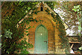
Mortuary Chapel
Mortuary Chapel in St.Peter-in-Eastgate churchyard http://www.geograph.org.uk/photo/5078335
Image: © Richard Croft
Taken: 15 Aug 2016
0.08 miles
10
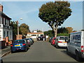
Langworthgate Mews
Mews houses on Langworthgate
Image: © Richard Croft
Taken: 14 Feb 2015
0.08 miles