IMAGES TAKEN NEAR TO
Gibson Road, LINCOLN, LN2 4NZ
Introduction
This page details the photographs taken nearby to Gibson Road, LN2 4NZ by members of the Geograph project.
The Geograph project started in 2005 with the aim of publishing, organising and preserving representative images for every square kilometre of Great Britain, Ireland and the Isle of Man.

There are currently over 7.5m images from over14,400 individuals and you can help contribute to the project by visiting https://www.geograph.org.uk
Image Map
Images are licensed for reuse under creativecommons.org/licenses/by-sa/2.0
Notes
- Clicking on the map will re-center to the selected point.
- The higher the marker number, the further away the image location is from the centre of the postcode.
Image Listing (7 Images Found)
Images are licensed for reuse under creativecommons.org/licenses/by-sa/2.0
Image
Details
Distance

2
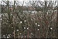
Snow-sided teasels by the Lincoln bypass
Photographed when it was safe to do so: I was in a traffic jam behind a 5-car pile-up!
Image: © Chris
Taken: 17 Mar 2018
0.11 miles
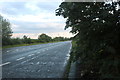
3
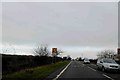
Queuing traffic warning sign on the A158 Lincoln
Image: © Steve Fareham
Taken: 8 Jan 2016
0.13 miles
4
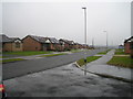
Glebe Park
Glebe Park, not a park but a housing estate on the north east outskirts of Lincoln.
Image: © Matthew Smith
Taken: 12 Feb 2006
0.22 miles
5
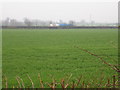
The Lincoln green belt?
This is the last remaining field between Glebe Park housing estate and the Lincoln bypass. I don't know how long it will remain this way. The bypass can be seen in the background.
Image: © Matthew Smith
Taken: 12 Feb 2006
0.22 miles
7
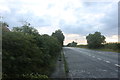
Parking area on the A158, Lincoln
This is part of the Lincoln Eastern Bypass, more is going to be finished soon.
Image: © David Howard
Taken: 6 Aug 2019
0.24 miles