IMAGES TAKEN NEAR TO
Flavian Road, LINCOLN, LN2 4GR
Introduction
This page details the photographs taken nearby to Flavian Road, LN2 4GR by members of the Geograph project.
The Geograph project started in 2005 with the aim of publishing, organising and preserving representative images for every square kilometre of Great Britain, Ireland and the Isle of Man.

There are currently over 7.5m images from over14,400 individuals and you can help contribute to the project by visiting https://www.geograph.org.uk
Image Map (Loading...)


Getting Data...Please wait
Leaflet Map data © OpenStreetMap
Images are licensed for reuse under creativecommons.org/licenses/by-sa/2.0
Notes
- Clicking on the map will re-center to the selected point.
- The higher the marker number, the further away the image location is from the centre of the postcode.
Image Listing (37 Images Found)
Images are licensed for reuse under creativecommons.org/licenses/by-sa/2.0
Image
Details
Distance
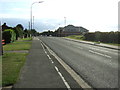
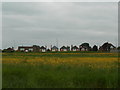
1
Green belt
Farmland between the edge of Lincoln and the ring road, likely to be developed in the near future
Image: © Richard Croft
Taken: 21 Apr 2009
0.02 miles
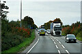
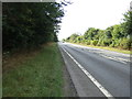
2

Night Fall
Sun setting on this rainy day.
Image: © Ian Paterson
Taken: 16 Jun 2007
0.02 miles
3
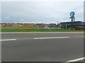
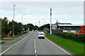
Starbucks Drive Thru and new houses off Lincoln Road
A modern Starbucks is located beside Lincoln Road. In the background a modern housing development stands on land that was formerly farmland on the edge of the city.
Image: © Graham Robson
Taken: 9 Jul 2023
0.05 miles