IMAGES TAKEN NEAR TO
Kipling Close, LINCOLN, LN2 4EW
Introduction
This page details the photographs taken nearby to Kipling Close, LN2 4EW by members of the Geograph project.
The Geograph project started in 2005 with the aim of publishing, organising and preserving representative images for every square kilometre of Great Britain, Ireland and the Isle of Man.

There are currently over 7.5m images from over14,400 individuals and you can help contribute to the project by visiting https://www.geograph.org.uk
Image Map (Loading...)


Getting Data...Please wait
Leaflet Map data © OpenStreetMap
Images are licensed for reuse under creativecommons.org/licenses/by-sa/2.0
Notes
- Clicking on the map will re-center to the selected point.
- The higher the marker number, the further away the image location is from the centre of the postcode.
Image Listing (21 Images Found)
Images are licensed for reuse under creativecommons.org/licenses/by-sa/2.0
Image
Details
Distance
1
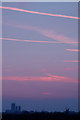
Cathedral Sunset
Sunset behind Lincoln Cathedral from a field on Glebe Park
Image: © John Bennett
Taken: 16 Oct 2007
0.05 miles

4
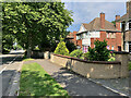
Nettleham Road, Lincoln
Also known by its less glamorous name, the B1182, the road is one of the main routes into the city centre from the north east.
Image: © Paul Harrop
Taken: 3 Jun 2022
0.17 miles
5
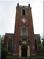
St.Giles' church
Originally St.Peter at Arches church by William Smith c1720-4, rebuilt here by W.G.Watkins in 1936.
Image: © Richard Croft
Taken: Unknown
0.17 miles
6
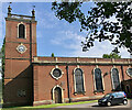
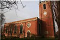
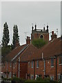
St Giles Parish Church, Lincoln
On Lamb Gardens/Marlowe Drive, the Grade II Listed church was designed in 1720 as the Church of St Peter at Arches, Lincoln. Demolished in 1930, it was re-erected and extended on the present site in 1936 by William Watkins of Lincoln.
Image: © Paul Harrop
Taken: 3 Jun 2022
0.17 miles
7
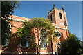
St Giles' Church, Lincoln, Lincolnshire
The parish church of St Giles in Lincoln
Image: © Gary Brothwell
Taken: 31 Aug 2010
0.18 miles
9
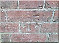
Ordnance Survey Cut Mark
This OS cut mark can be found on the NW face of St Giles Church. It marks a point 48.527m above mean sea level.
Image: © Adrian Dust
Taken: 24 Jul 2017
0.18 miles
10
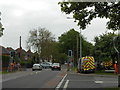
Traffic lights being erected at junction of Cabourne Avenue and Nettleham Road
Image: © Andrew Wilson
Taken: 10 Jun 2013
0.19 miles