IMAGES TAKEN NEAR TO
Welton, LINCOLN, LN2 3WB
Introduction
This page details the photographs taken nearby to LN2 3WB by members of the Geograph project.
The Geograph project started in 2005 with the aim of publishing, organising and preserving representative images for every square kilometre of Great Britain, Ireland and the Isle of Man.

There are currently over 7.5m images from over14,400 individuals and you can help contribute to the project by visiting https://www.geograph.org.uk
Image Map
Images are licensed for reuse under creativecommons.org/licenses/by-sa/2.0
Notes
- Clicking on the map will re-center to the selected point.
- The higher the marker number, the further away the image location is from the centre of the postcode.
Image Listing (9 Images Found)
Images are licensed for reuse under creativecommons.org/licenses/by-sa/2.0
Image
Details
Distance
2
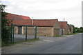
Honeywood Farm, near Dunholme, Lincolnshire
On Honeyholes Lane right in the NW corner of the square.
Image: © Kate Jewell
Taken: 14 Jun 2006
0.10 miles
3
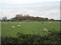
Sheep and Honeywood
Honeywood lies beyond Honeyholes Lane.
Image: © Jonathan Thacker
Taken: 24 Oct 2017
0.18 miles
4
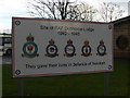
WWII airfield information sign
The William Farr school in Dunholme is built on part of the former Bomber Command airfield of RAF Dunholme Lodge. This sign displays the crests of those units that were based here
NB: The sign incorrectly displays the name of the airfield-the "l" is missing!
Image: © Tony Hibberd
Taken: 16 Dec 2012
0.19 miles
8
Entrance to Field House from Lincoln road
Image: © John Firth
Taken: 6 Jun 2011
0.23 miles
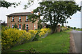
9
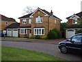
My new house
This is when we first looked at the house. I was very excited.
Image: © peter russell
Taken: 12 May 2007
0.24 miles