IMAGES TAKEN NEAR TO
Ryland Gardens, LINCOLN, LN2 3RX
Introduction
This page details the photographs taken nearby to Ryland Gardens, LN2 3RX by members of the Geograph project.
The Geograph project started in 2005 with the aim of publishing, organising and preserving representative images for every square kilometre of Great Britain, Ireland and the Isle of Man.

There are currently over 7.5m images from over14,400 individuals and you can help contribute to the project by visiting https://www.geograph.org.uk
Image Map
Images are licensed for reuse under creativecommons.org/licenses/by-sa/2.0
Notes
- Clicking on the map will re-center to the selected point.
- The higher the marker number, the further away the image location is from the centre of the postcode.
Image Listing (5 Images Found)
Images are licensed for reuse under creativecommons.org/licenses/by-sa/2.0
Image
Details
Distance
2
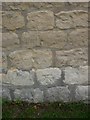
Cut Mark: Welton, Ryland Road
Cut bench mark on a former farm building, now private accommodation, at the junction of Ryland Road and Dunholme Road. See http://www.bench-marks.org.uk/bm32504 for details.
Image: © Brian Westlake
Taken: 16 Oct 2014
0.21 miles
4
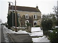
Ryland House
Ryland was a hamlet in the parish of Welton but is now subsumed in suburban estates. But a few traces of the old hamlet remain of which Ryland House is one.
Image: © Jonathan Thacker
Taken: 9 Feb 2012
0.23 miles
5
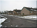
Eastfield Close
Typical of the bungalurbia which surrounds Welton.
Image: © Jonathan Thacker
Taken: 9 Feb 2012
0.25 miles