IMAGES TAKEN NEAR TO
Ermine Street, LINCOLN, LN2 3PR
Introduction
This page details the photographs taken nearby to Ermine Street, LN2 3PR by members of the Geograph project.
The Geograph project started in 2005 with the aim of publishing, organising and preserving representative images for every square kilometre of Great Britain, Ireland and the Isle of Man.

There are currently over 7.5m images from over14,400 individuals and you can help contribute to the project by visiting https://www.geograph.org.uk
Image Map
Images are licensed for reuse under creativecommons.org/licenses/by-sa/2.0
Notes
- Clicking on the map will re-center to the selected point.
- The higher the marker number, the further away the image location is from the centre of the postcode.
Image Listing (5 Images Found)
Images are licensed for reuse under creativecommons.org/licenses/by-sa/2.0
Image
Details
Distance
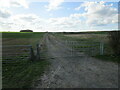
2
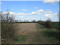
Farm track and stubble field near Whale Jaws
Image: © Jonathan Thacker
Taken: 25 Mar 2021
0.06 miles
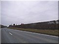
3
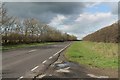
A15 road near RAF Scampton
It appears that the runway was built over the old Roman road which the A15 follows (Ermine street),so the road has to take a long curving detour.
Image: © J.Hannan-Briggs
Taken: 18 Mar 2012
0.13 miles
4
Cammeringham Top footpath
Footpath from Ermine Street to Middle Street across Cammeringham Top
Image: © Richard Croft
Taken: 28 Apr 2007
0.18 miles
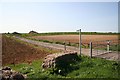
5
The beginning of a footpath to Cammeringham
Image: © Jonathan Thacker
Taken: 25 Mar 2021
0.19 miles