IMAGES TAKEN NEAR TO
Beck Lane, LINCOLN, LN2 3NX
Introduction
This page details the photographs taken nearby to Beck Lane, LN2 3NX by members of the Geograph project.
The Geograph project started in 2005 with the aim of publishing, organising and preserving representative images for every square kilometre of Great Britain, Ireland and the Isle of Man.

There are currently over 7.5m images from over14,400 individuals and you can help contribute to the project by visiting https://www.geograph.org.uk
Image Map
Images are licensed for reuse under creativecommons.org/licenses/by-sa/2.0
Notes
- Clicking on the map will re-center to the selected point.
- The higher the marker number, the further away the image location is from the centre of the postcode.
Image Listing (47 Images Found)
Images are licensed for reuse under creativecommons.org/licenses/by-sa/2.0
Image
Details
Distance
1

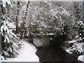
Ford and Footbridge at Beck Lane Dunholme
This ford on the outskirts of the village is close to the main A46 road to Market Rasen. There is a second ford to the north of the village at TF 093 346 in Watery Lane.
Image: © John Walton
Taken: 11 Apr 2010
0.02 miles
2
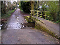
The Bridge over the beck at Beck Lane, Dunholme
Image: © Harry King
Taken: 23 Mar 2008
0.04 miles
3
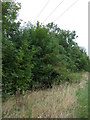
The Beck on Beck Lane
Taken on Saturday 29th March 2008
Image: © alex king
Taken: 29 Mar 2008
0.04 miles
6
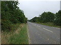
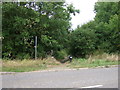
A46 towards Market Rasen
Heading north east on the outskirts of Dunholme.
Image: © JThomas
Taken: 6 Sep 2014
0.09 miles
7
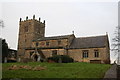
St.Chad's church, Dunholme, Lincs.
Largely Early English, much restored in 1853
Image: © Richard Croft
Taken: 3 Jan 2006
0.14 miles
8
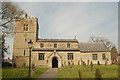
St Chad's Church, Dunholme
The parish church of St Chad at Dunholme in Lincolnshire
Image: © Gary Brothwell
Taken: 23 Apr 2010
0.14 miles
10
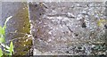
Ordnance Survey Cut Mark
This OS cut mark can be found on the north face of St Chad's Church. It marks a point 17.448m above mean sea level.
Image: © Adrian Dust
Taken: 22 Jul 2017
0.15 miles