IMAGES TAKEN NEAR TO
The Harrows, LINCOLN, LN2 3HA
Introduction
This page details the photographs taken nearby to The Harrows, LN2 3HA by members of the Geograph project.
The Geograph project started in 2005 with the aim of publishing, organising and preserving representative images for every square kilometre of Great Britain, Ireland and the Isle of Man.

There are currently over 7.5m images from over14,400 individuals and you can help contribute to the project by visiting https://www.geograph.org.uk
Image Map (Loading...)


Getting Data...Please wait
Leaflet Map data © OpenStreetMap
Images are licensed for reuse under creativecommons.org/licenses/by-sa/2.0
Notes
- Clicking on the map will re-center to the selected point.
- The higher the marker number, the further away the image location is from the centre of the postcode.
Image Listing (52 Images Found)
Images are licensed for reuse under creativecommons.org/licenses/by-sa/2.0
Image
Details
Distance
1
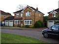
My new house
This is when we first looked at the house. I was very excited.
Image: © peter russell
Taken: 12 May 2007
0.09 miles
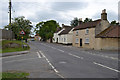
2
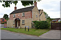
House in Sudbeck lane
From grass triangle on Lincoln road
Image: © John Firth
Taken: 6 Jun 2011
0.19 miles
3
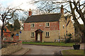
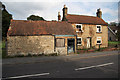
Sudbeck Lane
18th & 19th century cottage on Sudbeck Lane in Welton
Image: © Richard Croft
Taken: 25 Feb 2015
0.19 miles
4
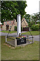
Village pump at Welton By Lincoln
At entrance of Sudbeck Lane on triangle
Image: © John Firth
Taken: 6 Jun 2011
0.20 miles
5
Lincoln Road from Sudbeck Lane
Looking towards Lincoln
Image: © John Firth
Taken: 6 Jun 2011
0.20 miles
6
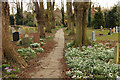
Churchyard path
Snowdrops beside the path to the beck in St.Mary's churchyard
Image: © Richard Croft
Taken: 25 Feb 2015
0.20 miles
7
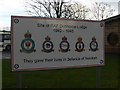
WWII airfield information sign
The William Farr school in Dunholme is built on part of the former Bomber Command airfield of RAF Dunholme Lodge. This sign displays the crests of those units that were based here
NB: The sign incorrectly displays the name of the airfield-the "l" is missing!
Image: © Tony Hibberd
Taken: 16 Dec 2012
0.21 miles
8
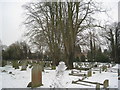
The churchyard, Welton
The footpath and avenue cut diagonally across the line of the graves.
Image: © Jonathan Thacker
Taken: 9 Feb 2012
0.21 miles
9
Cottage on Lincoln Road
Empty cottage with planning permission for two more houses in the grounds, on Lincoln Road in Welton
Image: © Richard Croft
Taken: 5 Sep 2010
0.21 miles
10
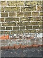
Cut Benchmark on 25 Vicarage Lane, Welton
Cut mark on the east face. See https://www.geograph.org.uk/photo/7445992 for a wider view and https://www.bench-marks.org.uk/bm183168 for details of the mark.
Image: © Brian Westlake
Taken: 1 Feb 2023
0.22 miles