IMAGES TAKEN NEAR TO
St. Edwards Drive, LINCOLN, LN2 2QR
Introduction
This page details the photographs taken nearby to St. Edwards Drive, LN2 2QR by members of the Geograph project.
The Geograph project started in 2005 with the aim of publishing, organising and preserving representative images for every square kilometre of Great Britain, Ireland and the Isle of Man.

There are currently over 7.5m images from over14,400 individuals and you can help contribute to the project by visiting https://www.geograph.org.uk
Image Map (Loading...)


Getting Data...Please wait
Leaflet Map data © OpenStreetMap
Images are licensed for reuse under creativecommons.org/licenses/by-sa/2.0
Notes
- Clicking on the map will re-center to the selected point.
- The higher the marker number, the further away the image location is from the centre of the postcode.
Image Listing (11 Images Found)
Images are licensed for reuse under creativecommons.org/licenses/by-sa/2.0
Image
Details
Distance
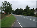
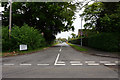
3
A158 Wragby Road, Sudbrooke
Looking towards Wragby.
Image: © Richard Vince
Taken: 16 Jun 2018
0.17 miles
4
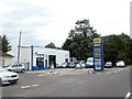
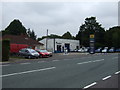
Barber's garage, UK fuel filling station, Sudbrooke
Image: © David Smith
Taken: 19 Sep 2018
0.17 miles
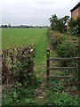
5
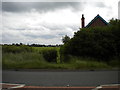
Public footpath to Reepham, Sudbrooke
Through a gap in the hedge off the A158 Wragby Road opposite the main part of the village.
Image: © Richard Vince
Taken: 16 Jun 2018
0.17 miles
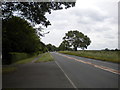
6
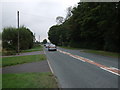
Wragby Road (A158)
Heading south west towards Lincoln.
Image: © JThomas
Taken: 6 Sep 2014
0.17 miles