IMAGES TAKEN NEAR TO
Lincoln Road, LINCOLN, LN2 2NG
Introduction
This page details the photographs taken nearby to Lincoln Road, LN2 2NG by members of the Geograph project.
The Geograph project started in 2005 with the aim of publishing, organising and preserving representative images for every square kilometre of Great Britain, Ireland and the Isle of Man.

There are currently over 7.5m images from over14,400 individuals and you can help contribute to the project by visiting https://www.geograph.org.uk
Image Map
Images are licensed for reuse under creativecommons.org/licenses/by-sa/2.0
Notes
- Clicking on the map will re-center to the selected point.
- The higher the marker number, the further away the image location is from the centre of the postcode.
Image Listing (10 Images Found)
Images are licensed for reuse under creativecommons.org/licenses/by-sa/2.0
Image
Details
Distance
1
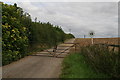
Road to the oilwell and to Greetwell Lane Farm
Image: © Chris
Taken: 5 Sep 2015
0.17 miles
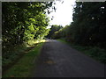
2
Old A46 south of Nettleham
Now marked as a byway.
Image: © Chris
Taken: 5 Sep 2015
0.20 miles
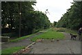
3

Old Lincoln Road
The course of Old Lincoln Road near Nettleham, now a leafy footpath
Image: © Richard Croft
Taken: 9 Nov 2006
0.20 miles
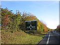
4
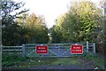
Road Closed
Old Lincoln Road near Nettleham, now bypassed
Image: © Richard Croft
Taken: 9 Nov 2006
0.20 miles
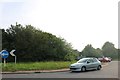
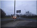
7
Lincoln Bypass - Approaching the (A46) Lincoln Road Roundabout
Image: © Alan Heardman
Taken: 28 Oct 2011
0.21 miles
8
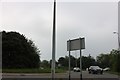
Roundabout on the A158 near Riseholme
It looks familiar https://www.geograph.org.uk/photo/5651813
Image: © David Howard
Taken: 24 Jun 2019
0.22 miles
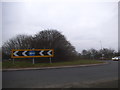
10
Roundabout on the A158 near Riseholme
Image: © David Howard
Taken: 13 Jan 2018
0.22 miles