IMAGES TAKEN NEAR TO
Deepdale Lane, LINCOLN, LN2 2LT
Introduction
This page details the photographs taken nearby to Deepdale Lane, LN2 2LT by members of the Geograph project.
The Geograph project started in 2005 with the aim of publishing, organising and preserving representative images for every square kilometre of Great Britain, Ireland and the Isle of Man.

There are currently over 7.5m images from over14,400 individuals and you can help contribute to the project by visiting https://www.geograph.org.uk
Image Map (Loading...)


Getting Data...Please wait
Leaflet Map data © OpenStreetMap
Images are licensed for reuse under creativecommons.org/licenses/by-sa/2.0
Notes
- Clicking on the map will re-center to the selected point.
- The higher the marker number, the further away the image location is from the centre of the postcode.
Image Listing (86 Images Found)
Images are licensed for reuse under creativecommons.org/licenses/by-sa/2.0
Image
Details
Distance
1
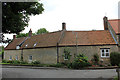
Walnut Farm house, barn and Stables, North Street, Nettleham
Grade II Listed late 17th century farm buildings with 19th century alterations and minor 20th century additions. The Parish Council website confusingly tells us 'It is now a rebuilt Walnut House, a house converted from the barn and two tasteful new bungalows'.
Image: © Jo and Steve Turner
Taken: 14 Jul 2020
0.11 miles
2
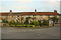
Crescent Cottages
Pretty stone cottages on The Crescent
Image: © Richard Croft
Taken: 29 May 2012
0.14 miles
3
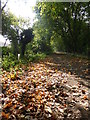
First signs of Autumn
On this footpath to the west of Nettleham
Image: © Graham Hogg
Taken: 29 Sep 2014
0.15 miles
4
Crescent Cottages
Cottages with cottage gardens on The Crescent http://www.geograph.org.uk/photo/2982815
Image: © Richard Croft
Taken: 29 May 2012
0.15 miles
5
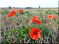
Late flowering poppies
In a harvested field near Nettleham
Image: © Graham Hogg
Taken: 29 Sep 2014
0.15 miles
6
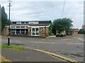
The Hub, Nettleham
A library and community cafe in the middle of Nettleham.
Image: © Graham Robson
Taken: 9 Jul 2023
0.19 miles
7
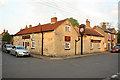
The Black Horse
Popular hostelry in Nettleham, parts of which date from before 1777 when it was the parish poor house
Image: © Richard Croft
Taken: 29 May 2012
0.19 miles
8
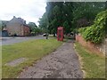
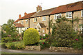
East Street, Nettleham
A road in the middle of Nettleham with a wide grass verge and pavement.
Image: © Graham Robson
Taken: 9 Jul 2023
0.21 miles
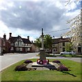
9
Nettleham War Memorial (left side view)
The following names are inscribed on this side:
EDWARD THESIGAR FRANKLAND HOOD DSO
CHARLES IVO SINCLAIR HOOD
MARTIN ARTHUR FRANKLAND HOOD
JOSEPH ATKIN
SIDNEY BAKER
FRED BELL
ARTHUR BLACKBOURN
JOHN ROBERT CAMM
FRED CAUNT
CHARLES HADDEN ELSOM
CHARLES ERNEST FARMERY
HENRY SCHOLEY FOW
LEONARD GREEN
JOSEPH HARE
LAWRENCE FREDERICK JUBB
Image: © Gerald England
Taken: 13 Apr 2019
0.21 miles
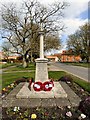
10
Nettleham War Memorial (right side view)
The following names are inscribed on this side:
EDWARD LENYCON
THOMAS PASK MILLINGTON
WILLIAM NICHOLSON
WALTER NEEDHAM
JOHN PARKER
WILLIAM PARKER
JOSEPH WILLIAM PROCTER
CHARLES ROBERTS
FRED ROBINSON
JOSEPH ROBINSON
SIDNEY SAWYER
JOSEPH SEARBY
ALFRED WRAY
CHARLES WARD
HARRY AUGUSTUS CHAMBER YARNELL
FRED SAWYER
Image: © Gerald England
Taken: 13 Apr 2019
0.21 miles