IMAGES TAKEN NEAR TO
Lysterfield End, LINCOLN, LN2 2GL
Introduction
This page details the photographs taken nearby to Lysterfield End, LN2 2GL by members of the Geograph project.
The Geograph project started in 2005 with the aim of publishing, organising and preserving representative images for every square kilometre of Great Britain, Ireland and the Isle of Man.

There are currently over 7.5m images from over14,400 individuals and you can help contribute to the project by visiting https://www.geograph.org.uk
Image Map
Images are licensed for reuse under creativecommons.org/licenses/by-sa/2.0
Notes
- Clicking on the map will re-center to the selected point.
- The higher the marker number, the further away the image location is from the centre of the postcode.
Image Listing (20 Images Found)
Images are licensed for reuse under creativecommons.org/licenses/by-sa/2.0
Image
Details
Distance
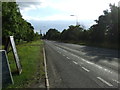
1
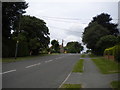
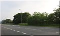
West end of Washdyke Lane, Nettleham
Looking towards the A46 near the western edge of the village.
Image: © Richard Vince
Taken: 16 Jun 2018
0.07 miles
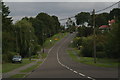
2
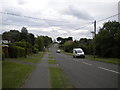
Washdyke Lane, Nettleham (1)
Looking towards the village centre from near its western edge.
Image: © Richard Vince
Taken: 16 Jun 2018
0.08 miles
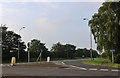
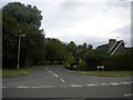
4
Washdyke Lane at the junction of Welton Road
Image: © David Howard
Taken: 24 Jun 2019
0.08 miles
6
Washdyke Lane at the junction of Welton Road
Image: © David Howard
Taken: 24 Jun 2019
0.09 miles
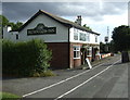
8
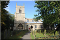
Nettleham Church
This picture was taken near my house. I live in the newsagents shop.
Image: © bradley Towler
Taken: 20 Oct 2008
0.11 miles
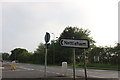
10
West end of Kingsway, Nettleham
Seen from Washdyke Lane.
Image: © Richard Vince
Taken: 16 Jun 2018
0.12 miles