IMAGES TAKEN NEAR TO
Imp Close, LINCOLN, LN2 2FQ
Introduction
This page details the photographs taken nearby to Imp Close, LN2 2FQ by members of the Geograph project.
The Geograph project started in 2005 with the aim of publishing, organising and preserving representative images for every square kilometre of Great Britain, Ireland and the Isle of Man.

There are currently over 7.5m images from over14,400 individuals and you can help contribute to the project by visiting https://www.geograph.org.uk
Image Map
Images are licensed for reuse under creativecommons.org/licenses/by-sa/2.0
Notes
- Clicking on the map will re-center to the selected point.
- The higher the marker number, the further away the image location is from the centre of the postcode.
Image Listing (13 Images Found)
Images are licensed for reuse under creativecommons.org/licenses/by-sa/2.0
Image
Details
Distance
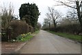
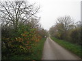
1
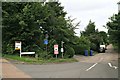
St. George's Lane, aka Grange Lane, off Riseholme Roundabout
Also the footpath to Riseholme.
Image: © Chris
Taken: 5 Sep 2015
0.13 miles
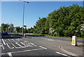
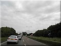
7
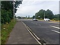
The A15, Lincoln
South along the A15 towards the roundabout where the A15 meets Riseholme Road and the A46.
Image: © Graham Robson
Taken: 9 Jul 2023
0.17 miles
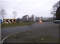
8
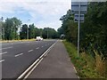
The A15, north of Lincoln
Looking north along the A15 road on the northern edge of Lincoln.
Image: © Graham Robson
Taken: 9 Jul 2023
0.18 miles
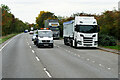
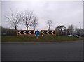
10
Queuing for roundabout on the A46 Lincoln bypass
Image: © Steve Fareham
Taken: 13 Jun 2014
0.22 miles