IMAGES TAKEN NEAR TO
Northfield Avenue, LINCOLN, LN2 2FB
Introduction
This page details the photographs taken nearby to Northfield Avenue, LN2 2FB by members of the Geograph project.
The Geograph project started in 2005 with the aim of publishing, organising and preserving representative images for every square kilometre of Great Britain, Ireland and the Isle of Man.

There are currently over 7.5m images from over14,400 individuals and you can help contribute to the project by visiting https://www.geograph.org.uk
Image Map
Images are licensed for reuse under creativecommons.org/licenses/by-sa/2.0
Notes
- Clicking on the map will re-center to the selected point.
- The higher the marker number, the further away the image location is from the centre of the postcode.
Image Listing (11 Images Found)
Images are licensed for reuse under creativecommons.org/licenses/by-sa/2.0
Image
Details
Distance
1
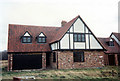
4 Beresford Drive
Arrington B type Potton timber frame house just about completed.
Image: © Jo and Steve Turner
Taken: 11 Feb 1990
0.07 miles
2
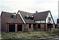
2 Beresford drive
Gransden E type Potton timber frame house just about completed.
Image: © Jo and Steve Turner
Taken: 11 Feb 1990
0.09 miles
3
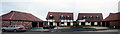
10 and 8 Maple Drive
Gamlinghay (show house) and Caxton type Potton timber frame houses.
Image: © Jo and Steve Turner
Taken: 11 Feb 1990
0.11 miles
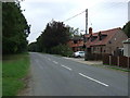
6
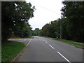
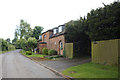
Scothern Lane,
Sudbrooke Looking north.
Junction with Church Lane.
Image: © JThomas
Taken: 6 Sep 2014
0.19 miles
8
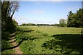
Ponies in Sudbrooke Park
Ponies in a paddock near New Ten Acre Covert off West Drive
Image: © Richard Croft
Taken: 2 May 2007
0.21 miles
9
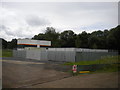
Site accommodation near Sudbrooke Park
Image: © Richard Vince
Taken: 16 Jun 2018
0.23 miles