IMAGES TAKEN NEAR TO
Laughton Way North, LINCOLN, LN2 2AW
Introduction
This page details the photographs taken nearby to Laughton Way North, LN2 2AW by members of the Geograph project.
The Geograph project started in 2005 with the aim of publishing, organising and preserving representative images for every square kilometre of Great Britain, Ireland and the Isle of Man.

There are currently over 7.5m images from over14,400 individuals and you can help contribute to the project by visiting https://www.geograph.org.uk
Image Map (Loading...)


Getting Data...Please wait
Leaflet Map data © OpenStreetMap
Images are licensed for reuse under creativecommons.org/licenses/by-sa/2.0
Notes
- Clicking on the map will re-center to the selected point.
- The higher the marker number, the further away the image location is from the centre of the postcode.
Image Listing (16 Images Found)
Images are licensed for reuse under creativecommons.org/licenses/by-sa/2.0
Image
Details
Distance
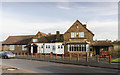
3
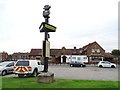
"The Lincoln Imp" pub at Ermine, Lincoln
Image: © Neil Theasby
Taken: 12 Oct 2015
0.16 miles
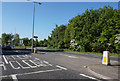
6
Queen Elizabeth Road at Pine Close
Ermine, Lincoln.
Image: © Ian S
Taken: 19 May 2018
0.17 miles
7
The Lincoln Imp
Pub on the Ermine Estate named after the famous Lincoln Imp, an evil sprite turned to stone found in the Angel Choir of Lincoln cathedral
Image: © Richard Croft
Taken: Unknown
0.17 miles
8
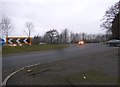
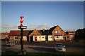
St. George's Lane, aka Grange Lane, off Riseholme Roundabout
Also the footpath to Riseholme.
Image: © Chris
Taken: 5 Sep 2015
0.17 miles

10
Lincoln Imp pub
Currently the pub is up To Let.
Image: © Julian P Guffogg
Taken: 23 Jan 2016
0.17 miles