IMAGES TAKEN NEAR TO
Nettleham Road, LINCOLN, LN2 1RQ
Introduction
This page details the photographs taken nearby to Nettleham Road, LN2 1RQ by members of the Geograph project.
The Geograph project started in 2005 with the aim of publishing, organising and preserving representative images for every square kilometre of Great Britain, Ireland and the Isle of Man.

There are currently over 7.5m images from over14,400 individuals and you can help contribute to the project by visiting https://www.geograph.org.uk
Image Map
Images are licensed for reuse under creativecommons.org/licenses/by-sa/2.0
Notes
- Clicking on the map will re-center to the selected point.
- The higher the marker number, the further away the image location is from the centre of the postcode.
Image Listing (117 Images Found)
Images are licensed for reuse under creativecommons.org/licenses/by-sa/2.0
Image
Details
Distance
1
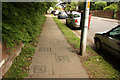
Anti-tank defence
Slots in the pavement for the insertion of vertical anti-tank rails where the City defensive perimeter crossed Nettleham Road
Image: © Richard Croft
Taken: 1 Jun 2013
0.03 miles
2
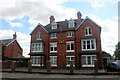
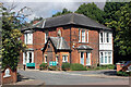
The Lodge, 38-40 Nettleham Road, Lincoln
Pair of houses by joiner/builder George Allis who is listed as architect as well. Planning for the houses was approved in May 1899. Mrs L Harding had a garage added to 40 in 1934, architect George Robinson Cuthbert Harding (1875-1955). No.40 also had an extension with lift in 1995. Dr S Green had had a garage added to no.38 in 1920 with the architect given as 'Harding C'. The planning is also marked 'Superseded'. It looks as if the building was converted to flats c.1995, The Lodge (Nettleham Road) Management Co. Ltd. being incorporated on the 3rd February 1995 but remaining dormant for the first couple of years. In 2019 the building underwent refurbishment with the maintenance cost rising by about £40k from the year before. In 2021 around £25.5k was spent on the new front railings/wall and car park.
Image: © Jo and Steve Turner
Taken: 5 Aug 2022
0.06 miles
3
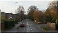
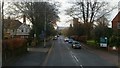
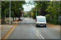
Nettleham Road, B1182, Lincoln, 1
Heading into the city on the park and ride bus by the turn for Manor Road.
Image: © Jonathan Billinger
Taken: 24 Nov 2018
0.07 miles
4
Orchard House, 54 Nettleham Road, Lincoln
Davis, Caldwell and Albarn designed house with unusual Dutch style gable ends. Planning was approved in May 1951 and it was built for W F Moor. It is a 1,839 sq ft house with two bedrooms on the ground floor and two on the first floor.
Image: © Jo and Steve Turner
Taken: 5 Aug 2022
0.09 miles
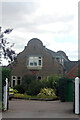
5
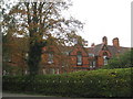
17 Nettleham Road, Lincoln
Initially called The Uplands it was built for Henry Slack Rainforth and has a datestone for 1883. Architect/builder was W Penney and notes on the planning said the outlet for Drainage was to be reconsidered. Rainforth designed and added an ingle nook in 1906 and in 1909 'out offices and additions'. In 1912 a 'motor house' was added, architect M A Hall. Bromhead Nursing Home purchased it in 1926 and it is now (2022) Dormer House, physiotherapy and audiology departments of Circle Health Group's 'The Lincoln Hospital'. An archaeological watching brief took place in 2005, in an attempt to locate the line of the Roman Lincoln Aqueduct. All that was found were modern deposits, an earlier ground surface and a brick filled and backfilled cellar, which had been a part of Dormer House. (The aqueduct ran parallel to Nettleham Road on the north west side and is known to come at least as far as no.29's garden).
Image: © Jo and Steve Turner
Taken: 5 Aug 2022
0.09 miles
6
Nettleham Road, B1182, Lincoln, 2
Heading into the city on the park and ride bus by the turn for Lincoln Hospital.
Image: © Jonathan Billinger
Taken: 24 Nov 2018
0.09 miles
7
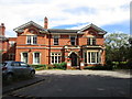
The Lincoln Hospital
A BMI Healthcare Hospital.
Image: © Jonathan Thacker
Taken: 21 Sep 2010
0.09 miles
10

War graves
War graves in Newport Cemetery
Image: © Richard Croft
Taken: 19 Feb 2014
0.11 miles