IMAGES TAKEN NEAR TO
Northgate, LINCOLN, LN2 1QS
Introduction
This page details the photographs taken nearby to Northgate, LN2 1QS by members of the Geograph project.
The Geograph project started in 2005 with the aim of publishing, organising and preserving representative images for every square kilometre of Great Britain, Ireland and the Isle of Man.

There are currently over 7.5m images from over14,400 individuals and you can help contribute to the project by visiting https://www.geograph.org.uk
Image Map
Images are licensed for reuse under creativecommons.org/licenses/by-sa/2.0
Notes
- Clicking on the map will re-center to the selected point.
- The higher the marker number, the further away the image location is from the centre of the postcode.
Image Listing (2041 Images Found)
Images are licensed for reuse under creativecommons.org/licenses/by-sa/2.0
Image
Details
Distance
2
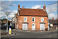
Old Choir School, 3 Nettleham Road, Lincoln
Originally Hursley Lodge it was part of 1 Northgate, first a coach house, then the schoolroom of 1887, but is now a separate dwelling. The conservatory and railings were added in 2005 when it became a physiotherapy practice. In 2016 it was reverted to a dwelling and seems to have had internal amendments to become a two bedroom holiday let. Sold in March 2022 it appears to be a private home again.
Image: © Jo and Steve Turner
Taken: 5 Aug 2022
0.04 miles
3
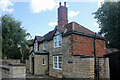
Heatherley, 8 Nettleham Road, Lincoln
Padley's 1842 map appears to show this (1830s?) house with another building adjoining the front and on the edge of the roadway. The 1887 town plan clearly shows it with a front garden as now (possibly the road is wider and garden reduced). A row of cottages, probably removed in the 1930s, were numbered 2-8 and this was number 9 at that time. It is now a 3/4 bedroom 1,557 sq ft house having had a kitchen and bedroom added in 1911 by Wright & Son.
Image: © Jo and Steve Turner
Taken: 5 Aug 2022
0.04 miles
4
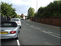
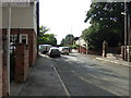
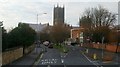
Junction of Nettleham Road and Northgate, Lincoln
Image: © Neil Theasby
Taken: 12 Oct 2015
0.04 miles
5
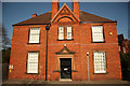
Northgate House
Late 18th century, grade II listed house on Nettleham Road
Image: © Richard Croft
Taken: 26 Oct 2011
0.04 miles
6
House on Nettleham Road, Lincoln
Attractive house of stone and brick construction on the eastern side of the road
Image: © Paul Harrop
Taken: 3 Jun 2022
0.05 miles
7
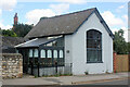
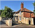
Stonefield Lodge, 26 Church Lane, Lincoln
The gate lodge to Stonefield House it was probably built in the 1860s. As far as I can tell, Stonefield house is not in my 1857 directory but is listed by 1867. It was enlarged in 1892 and appears to have been extended subsequently.
Image: © Jo and Steve Turner
Taken: 5 Aug 2022
0.05 miles
9
Nettleham Road, B1182, Lincoln, 4
Heading into the city on the park and ride bus at the junction with Northgate.
Image: © Jonathan Billinger
Taken: 24 Nov 2018
0.06 miles
10
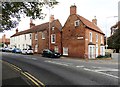
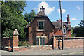
Bromhead Hospital
Church Lane front of the Bromhead Hospital http://www.geograph.org.uk/photo/2795545 added in 1927
The Institution for Nurses was founded by Mrs.A.F.Bromhead in May 1866, "The Red House" brick and terracotta hospital was built in 1887 and named after the founder. It was enlarged later in the 19th century and in 1927, taken over by the NHS in 1948, but in 1981 became an independent hospital before being sold to Nuffield Hospitals in 2001. It is now the BMI Lincoln private hospital http://www.bmihealthcare.co.uk/hospital/details?gclid=CMPwj6KFjq4CFQwgfAodM2BXhA&p_hosp_name=The%20Lincoln%20Hospital&p_hosp_id=269
Image: © Richard Croft
Taken: 3 Feb 2012
0.06 miles