IMAGES TAKEN NEAR TO
Ernie White Close, LN1 4AT
Introduction
This page details the photographs taken nearby to Ernie White Close, LN1 4AT by members of the Geograph project.
The Geograph project started in 2005 with the aim of publishing, organising and preserving representative images for every square kilometre of Great Britain, Ireland and the Isle of Man.

There are currently over 7.5m images from over14,400 individuals and you can help contribute to the project by visiting https://www.geograph.org.uk
Image Map
Images are licensed for reuse under creativecommons.org/licenses/by-sa/2.0
Notes
- Clicking on the map will re-center to the selected point.
- The higher the marker number, the further away the image location is from the centre of the postcode.
Image Listing (7 Images Found)
Images are licensed for reuse under creativecommons.org/licenses/by-sa/2.0
Image
Details
Distance
1
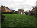
Suburban development, Saxilby
Some care has been taken in the positioning of these houses (which are in two streets) to create a miniature 'village green' effect.
Image: © Jonathan Thacker
Taken: 23 Dec 2014
0.12 miles
2
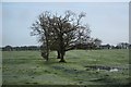
Ridge & furrow
Ridge & furrow undulations in a field off Sykes Lane on a misty winter morning
Image: © Richard Croft
Taken: 9 Dec 2009
0.17 miles
3
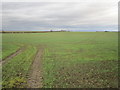
Footpath leading off Sykes Lane, Saxilby
Image: © Chris Morgan
Taken: 28 Mar 2017
0.19 miles
4

Ridge & furrow
Melting snow starkly revealing ridge & furrow undulations in a field off Sykes Lane http://www.geograph.org.uk/photo/1611976
Image: © Richard Croft
Taken: 12 Feb 2012
0.20 miles
5
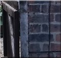
Ordnance Survey Cut Mark
This OS cut mark can be found on No121 High Street. It marks a point 11.269m above mean sea level.
Image: © Adrian Dust
Taken: 21 Jul 2017
0.24 miles
6
Farmland near Saxilby
Typical of the area drained by the River Till and its tributaries.
Image: © Jonathan Thacker
Taken: 23 Dec 2014
0.24 miles
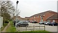
7
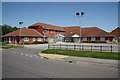
Saxilby surgery
Shared general practice surgery on Sykes Lane
Image: © Richard Croft
Taken: 31 May 2009
0.24 miles