IMAGES TAKEN NEAR TO
Breedon Drive, LINCOLN, LN1 3XA
Introduction
This page details the photographs taken nearby to Breedon Drive, LN1 3XA by members of the Geograph project.
The Geograph project started in 2005 with the aim of publishing, organising and preserving representative images for every square kilometre of Great Britain, Ireland and the Isle of Man.

There are currently over 7.5m images from over14,400 individuals and you can help contribute to the project by visiting https://www.geograph.org.uk
Image Map
Images are licensed for reuse under creativecommons.org/licenses/by-sa/2.0
Notes
- Clicking on the map will re-center to the selected point.
- The higher the marker number, the further away the image location is from the centre of the postcode.
Image Listing (21 Images Found)
Images are licensed for reuse under creativecommons.org/licenses/by-sa/2.0
Image
Details
Distance
1
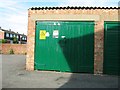
Electricity sub station, Breedon Drive
Image: © Alex McGregor
Taken: 25 Jul 2013
0.07 miles
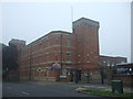
2
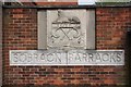
Sobraon Barracks
Sign at the historic HQ of the Lincolnshire Regiment http://www.geograph.org.uk/photo/89174
Image: © Richard Croft
Taken: 14 Apr 2009
0.12 miles
3
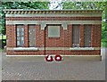
Lincolnshire Regiment Memorial - East Side
This monument to the soldiers of the Lincolnshire Regiment was unveiled on 6th October 2012 and stands in Sobraon Park amongst housing on the part of the barracks site
Image: © Phil Gresham
Taken: 8 Jun 2013
0.13 miles
4
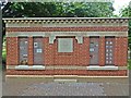
Lincolnshire Regiment Memorial - West Side
This monument to the soldiers of the Lincolnshire Regiment was unveiled on 6th October 2012 and stands in Sobraon Park amongst housing on the part of the barracks site
Image: © Phil Gresham
Taken: 8 Jun 2013
0.13 miles
5
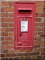
Lincoln, Sobraon Barracks
Post box with OS cut bench mark below on a former WD building at the north-west corner of Sobraon Barracks. See http://www.geograph.org.uk/photo/5122395 for a wider view and http://www.bench-marks.org.uk/bm30112 for details of the mark.
Image: © Brian Westlake
Taken: 28 Aug 2016
0.13 miles
6
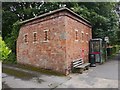
Sobraon Barracks, Lincoln
This former WD building carries a post box and OS cut bench mark on the right-hand face. See http://www.geograph.org.uk/photo/5122386 for a close-up and http://www.bench-marks.org.uk/bm30112 for details of the mark.
Image: © Brian Westlake
Taken: 28 Aug 2016
0.13 miles
7
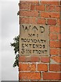
Lincoln, Sobraon Barracks, boundary stone
Boundary stone set in the angle of a building at the north-west corner of Sobraon Barracks, Lincoln. See http://www.geograph.org.uk/photo/5122395 for a wider view.
Image: © Brian Westlake
Taken: 28 Aug 2016
0.13 miles
8
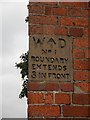
Old Boundary Marker by the B1398, Burton Road, Lincoln Parish
Estate Boundary Marker - War Department by the B1398, in parish of Lincoln (Lincoln District), Site of former Sobraon Barracks, in corner of army building.
To be surveyed
Milestone Society National ID: LI_WDLINS01em.
Image: © Milestone Society
Taken: Unknown
0.13 miles
10
Sobraon Barracks
Now a Territorial Army Centre.
Image: © JThomas
Taken: 6 Sep 2014
0.16 miles