IMAGES TAKEN NEAR TO
Riseholme Road, LINCOLN, LN1 3SL
Introduction
This page details the photographs taken nearby to Riseholme Road, LN1 3SL by members of the Geograph project.
The Geograph project started in 2005 with the aim of publishing, organising and preserving representative images for every square kilometre of Great Britain, Ireland and the Isle of Man.

There are currently over 7.5m images from over14,400 individuals and you can help contribute to the project by visiting https://www.geograph.org.uk
Image Map
Images are licensed for reuse under creativecommons.org/licenses/by-sa/2.0
Notes
- Clicking on the map will re-center to the selected point.
- The higher the marker number, the further away the image location is from the centre of the postcode.
Image Listing (10 Images Found)
Images are licensed for reuse under creativecommons.org/licenses/by-sa/2.0
Image
Details
Distance
3
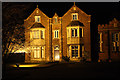
Bishop Grosseteste University College
Victorian buildings on the Bishop Grosseteste campus http://www.bishopg.ac.uk/
Image: © Richard Croft
Taken: 1 Jan 2012
0.11 miles
4
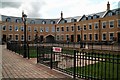
Stylish new development off Riseholme Road, Lincoln
Image: © Chris
Taken: 12 Sep 2015
0.13 miles
5
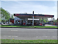
Garage and Car hire, Riseholme Road, Lincoln
Image: © Julian P Guffogg
Taken: 10 Apr 2011
0.13 miles
6
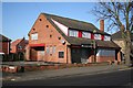
The Lark
The Lark has been closed and boarded up for about 3 years now ... with an uncertain future.
Image: © Richard Croft
Taken: 11 Feb 2008
0.21 miles
7
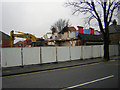
The end of The Lark
Long-closed pub The Lark http://www.geograph.org.uk/photo/688265 being demolished
Image: © Richard Croft
Taken: 5 Feb 2010
0.21 miles
9
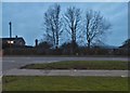
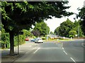
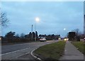
Riseholme Road, Ermine
Looking towards Francis School
Image: © David Howard
Taken: 13 Jan 2018
0.21 miles
10

"The Lark", Newport
Another former pub
Image: © Andrew Wilson
Taken: 27 Nov 2009
0.24 miles