IMAGES TAKEN NEAR TO
Langham Road, ALFORD, LN13 9SH
Introduction
This page details the photographs taken nearby to Langham Road, LN13 9SH by members of the Geograph project.
The Geograph project started in 2005 with the aim of publishing, organising and preserving representative images for every square kilometre of Great Britain, Ireland and the Isle of Man.

There are currently over 7.5m images from over14,400 individuals and you can help contribute to the project by visiting https://www.geograph.org.uk
Image Map
Images are licensed for reuse under creativecommons.org/licenses/by-sa/2.0
Notes
- Clicking on the map will re-center to the selected point.
- The higher the marker number, the further away the image location is from the centre of the postcode.
Image Listing (1 Images Found)
Images are licensed for reuse under creativecommons.org/licenses/by-sa/2.0
Image
Details
Distance
1
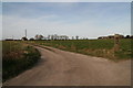
Drive to Wesley House
Supposed to be a public footpath running roughly in line with the drive, but it is not marked. However behind the camera is a footpath sign for a path going in the opposite direction: only the third such sign I have seen today. See also Image], Image] and Image
This is an area richly served with footpaths. However most of them are not signposted, and many are impossible to find or have been fenced over. I have complained about a path near here after a previous walk (or planned walk), only to be told it was a low priority path. I was not even given a date by which the problem would be fixed, and it still isn't.
Image: © Chris
Taken: 22 Mar 2015
0.14 miles