IMAGES TAKEN NEAR TO
Sea Lane, ALFORD, LN13 9RN
Introduction
This page details the photographs taken nearby to Sea Lane, LN13 9RN by members of the Geograph project.
The Geograph project started in 2005 with the aim of publishing, organising and preserving representative images for every square kilometre of Great Britain, Ireland and the Isle of Man.

There are currently over 7.5m images from over14,400 individuals and you can help contribute to the project by visiting https://www.geograph.org.uk
Image Map (Loading...)


Getting Data...Please wait
Leaflet Map data © OpenStreetMap
Images are licensed for reuse under creativecommons.org/licenses/by-sa/2.0
Notes
- Clicking on the map will re-center to the selected point.
- The higher the marker number, the further away the image location is from the centre of the postcode.
Image Listing (11 Images Found)
Images are licensed for reuse under creativecommons.org/licenses/by-sa/2.0
Image
Details
Distance
3
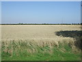
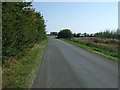
Crop field near Ryluc Farm
North of Sea Lane.
Image: © JThomas
Taken: 11 Sep 2015
0.03 miles
5
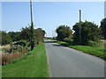
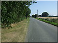
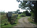
Sea Lane
Heading north east near Ryluc Farm.
Image: © JThomas
Taken: 11 Sep 2015
0.07 miles
6
Hay bales in Lincolnshire
Trailer to the side to transport?
Image: © Richard Hoare
Taken: 24 Feb 2011
0.11 miles
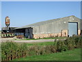
8
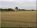
Field Finished
This harvester has finished this field and will no doubt be busy later in the day with its next job.
Image: © Michael Patterson
Taken: 23 Aug 2006
0.15 miles
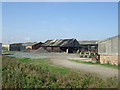
9
Entrance to Olcote Farm Caravan Site
Off Sea Lane.
Image: © JThomas
Taken: 11 Sep 2015
0.16 miles
10
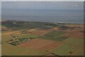
Jolly Common, Huttoft, to the coast: aerial 2023 (1)
Image: © Chris
Taken: 23 Sep 2023
0.22 miles