IMAGES TAKEN NEAR TO
Mumby Road, ALFORD, LN13 9RA
Introduction
This page details the photographs taken nearby to Mumby Road, LN13 9RA by members of the Geograph project.
The Geograph project started in 2005 with the aim of publishing, organising and preserving representative images for every square kilometre of Great Britain, Ireland and the Isle of Man.

There are currently over 7.5m images from over14,400 individuals and you can help contribute to the project by visiting https://www.geograph.org.uk
Image Map (Loading...)


Getting Data...Please wait
Leaflet Map data © OpenStreetMap
Images are licensed for reuse under creativecommons.org/licenses/by-sa/2.0
Notes
- Clicking on the map will re-center to the selected point.
- The higher the marker number, the further away the image location is from the centre of the postcode.
Image Listing (49 Images Found)
Images are licensed for reuse under creativecommons.org/licenses/by-sa/2.0
Image
Details
Distance
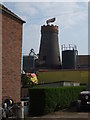
1
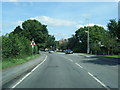
A52 Mumby Road looking toward Huttoft Mill
Image: © Colin Pyle
Taken: 6 Aug 2013
0.02 miles
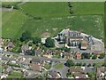
4
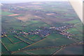
Huttoft: aerial 2014
In the strange light of a December afternoon.
The disused Sutton Branch Line (railway, now mostly a walkway) runs past on the left. See: Image] and Image
For aerial films of this area see: https://www.youtube.com/watch?v=wwhVamd4j6E and https://www.youtube.com/watch?v=zZjqzcMFXi8
These are LiDAR films of the Wolds and Marshes east of Louth. The films are narrated by Jim Broadbent. The land is colour-coded according to its elevation. The films show how the landscape was reclaimed for salt making and grazing. Footage includes ancient river systems, settlements, salterns and ridge and furrow. Produced for the Lincolnshire Coastal Grazing Marshes Project, which has now terminated.
Image: © Chris
Taken: 6 Dec 2014
0.05 miles
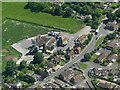
5
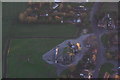
Huttoft to the sea: aerial 2014
Looking across the disused Sutton Branch Line railway, now mostly a walkway - see Image] and Image
For aerial films of this area see: https://www.youtube.com/watch?v=wwhVamd4j6E and https://www.youtube.com/watch?v=zZjqzcMFXi8
These are LiDAR films of the Wolds and Marshes east of Louth. The films are narrated by Jim Broadbent. The land is colour-coded according to its elevation. The films show how the landscape was reclaimed for salt making and grazing. Footage includes ancient river systems, settlements, salterns and ridge and furrow. Produced for the Lincolnshire Coastal Grazing Marshes Project, which has now terminated.
Image: © Chris
Taken: 6 Dec 2014
0.05 miles
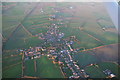
6
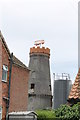
Huttoft Mill
The mill of four sails worked until 1945.
Image: © J.Hannan-Briggs
Taken: 29 Jul 2012
0.05 miles
7
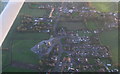
Huttoft: aerial 2014
In the strange light of a late afternoon in December.
For aerial films of this area see: https://www.youtube.com/watch?v=wwhVamd4j6E and https://www.youtube.com/watch?v=zZjqzcMFXi8
These are LiDAR films of the Wolds and Marshes east of Louth. The films are narrated by Jim Broadbent. The land is colour-coded according to its elevation. The films show how the landscape was reclaimed for salt making and grazing. Footage includes ancient river systems, settlements, salterns and ridge and furrow. Produced for the Lincolnshire Coastal Grazing Marshes Project, which has now terminated.
Image: © Chris
Taken: 6 Dec 2014
0.06 miles
8
Huttoft Mill: aerial 2014
In the strange light of a late afternoon in December.
For aerial films of this area see: https://www.youtube.com/watch?v=wwhVamd4j6E and https://www.youtube.com/watch?v=zZjqzcMFXi8
These are LiDAR films of the Wolds and Marshes east of Louth. The films are narrated by Jim Broadbent. The land is colour-coded according to its elevation. The films show how the landscape was reclaimed for salt making and grazing. Footage includes ancient river systems, settlements, salterns and ridge and furrow. Produced for the Lincolnshire Coastal Grazing Marshes Project, which has now terminated.
Image: © Chris
Taken: 6 Dec 2014
0.06 miles
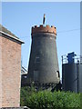
10
Mill at Huttoft
A grade II listed building, the mill lost its sails during a storm in 1945, prior to that it had been a working mill for about a century. Constructed in the 19th century (circa 1820) with 20th century alterations.The bricks have been painted in black bitumen.
Image: © Richard Hoare
Taken: 22 Apr 2011
0.07 miles