IMAGES TAKEN NEAR TO
Cumberworth Road, ALFORD, LN13 9LA
Introduction
This page details the photographs taken nearby to Cumberworth Road, LN13 9LA by members of the Geograph project.
The Geograph project started in 2005 with the aim of publishing, organising and preserving representative images for every square kilometre of Great Britain, Ireland and the Isle of Man.

There are currently over 7.5m images from over14,400 individuals and you can help contribute to the project by visiting https://www.geograph.org.uk
Image Map (Loading...)


Getting Data...Please wait
Leaflet Map data © OpenStreetMap
Images are licensed for reuse under creativecommons.org/licenses/by-sa/2.0
Notes
- Clicking on the map will re-center to the selected point.
- The higher the marker number, the further away the image location is from the centre of the postcode.
Image Listing (17 Images Found)
Images are licensed for reuse under creativecommons.org/licenses/by-sa/2.0
Image
Details
Distance
2
Oh dear, not another blocked footpath: at Mumby
See also Image
A ditch and sturdy barbed wire fence bar the way. Needless to say there is no footpath signpost either. Best forgotten about, eh?
This is an area richly served with footpaths. However most of them are not signposted, and many are impossible to find or have been fenced over. I have complained about a path near here after a previous walk (or planned walk), only to be told it was a low priority path. I was not even given a date by which the problem would be fixed, and it still isn't.
Image: © Chris
Taken: 22 Mar 2015
0.09 miles
3
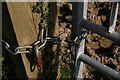
Where once there was a footpath NE from Main Drain, Mumby
Not any more, it seems. The gate is secured with a shackle which is more than finger-tight (see Image). The exit to the north has a sturdy barbed wire fence across it.
This is an area richly served with footpaths. However most of them are not signposted, and many are impossible to find or have been fenced over. I have complained about a path near here after a previous walk (or planned walk), only to be told it was a low priority path. I was not even given a date by which the problem would be fixed, and it still isn't.
Image: © Chris
Taken: 22 Mar 2015
0.11 miles
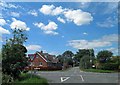
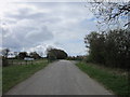
4
Footpath Mumb64/1 through Mumby
There is no sign at the road but my map and GPS both confirm that the path runs straight ahead.
I could find no way through. Why should there be? During my afternoon in Mumby, which is a maze of footpaths, I have been met more often than not by impenetrable hedges, and barbed wire and electric fences. I have seen I think only four stiles, and three of those were broken. I have seen only three footpath signs all day.
A previous complaint about one of the blocked paths met that it was a low priority path which would be fixed if money became available - which clearly hasn't happened.
After getting badly scratched trying to find a way through, once again I was forced to retreat. A thankless day out.
Image: © Chris
Taken: 19 Aug 2015
0.11 miles
5
Footpath by Main Drain, Mumby
See Image Yet another unmarked and blocked path near Mumby. The shackle, right, is more than finger-tight. The only way is over the top, then back again when you can't get out the other end. See also Image
This is an area richly served with footpaths. However most of them are not signposted, and many are impossible to find or have been fenced over. I have complained about a path near here after a previous walk (or planned walk), only to be told it was a low priority path. I was not even given a date by which the problem would be fixed, and it still isn't.
Image: © Chris
Taken: 22 Mar 2015
0.14 miles
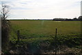
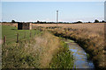
8
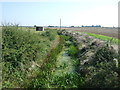
Main Drain
Looking south east from the bridge on Washdyke Lane.
Image: © JThomas
Taken: 11 Sep 2015
0.15 miles
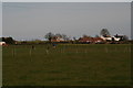
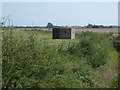
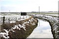
9
Main Drain
Late Summer contrasting view http://www.geograph.org.uk/photo/1162382 of Main Drain and WW2 pillbox near Cumberworth
Image: © Richard Croft
Taken: 3 Sep 2010
0.16 miles
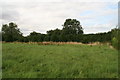
10
Main Drain
WW2 pillbox by Main Drain near Mumby
Image: © Richard Croft
Taken: 13 Feb 2009
0.17 miles