IMAGES TAKEN NEAR TO
Alder Place, ALFORD, LN13 9BZ
Introduction
This page details the photographs taken nearby to Alder Place, LN13 9BZ by members of the Geograph project.
The Geograph project started in 2005 with the aim of publishing, organising and preserving representative images for every square kilometre of Great Britain, Ireland and the Isle of Man.

There are currently over 7.5m images from over14,400 individuals and you can help contribute to the project by visiting https://www.geograph.org.uk
Image Map (Loading...)


Getting Data...Please wait
Leaflet Map data © OpenStreetMap
Images are licensed for reuse under creativecommons.org/licenses/by-sa/2.0
Notes
- Clicking on the map will re-center to the selected point.
- The higher the marker number, the further away the image location is from the centre of the postcode.
Image Listing (8 Images Found)
Images are licensed for reuse under creativecommons.org/licenses/by-sa/2.0
Image
Details
Distance
1

Alford fire station
Alford fire station, Willoughby Road, Alford, Lincolnshire
Image: © Kevin Hale
Taken: 4 Aug 2010
0.04 miles
2
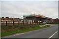
New build in Alford: yet more new houses
Though no shortage of housing has been identified in the area, the government continues to set targets for ever more houses.
Image: © Chris
Taken: 17 Jun 2014
0.05 miles
3
Bridgeways
New housing development off Willoughby Road, Alford.
Image: © JThomas
Taken: 29 May 2020
0.11 miles
4
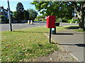
South Street, Alford
Showing position of Postbox No. LN13 815.
See Image] for postbox.
Image: © JThomas
Taken: 29 May 2020
0.13 miles
5
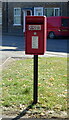
Elizabeth II postbox on South Street, Alford
Postbox No. LN13 815.
See Image] for context.
Image: © JThomas
Taken: 29 May 2020
0.14 miles
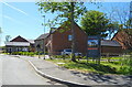
6
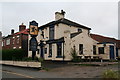
The Black Horse
Pub c1820 on South Street
Image: © Richard Croft
Taken: 3 Sep 2010
0.17 miles
7
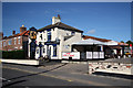
Black Horse, South Street: 2014
From the blackboard outside and posters in the window it still seems to be open.
Image: © Chris
Taken: 17 Jun 2014
0.21 miles
8
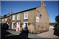
The White Hart
Pub c1840 on South Street
Image: © Richard Croft
Taken: 3 Sep 2010
0.24 miles