IMAGES TAKEN NEAR TO
Tothill, ALFORD, LN13 0NJ
Introduction
This page details the photographs taken nearby to LN13 0NJ by members of the Geograph project.
The Geograph project started in 2005 with the aim of publishing, organising and preserving representative images for every square kilometre of Great Britain, Ireland and the Isle of Man.

There are currently over 7.5m images from over14,400 individuals and you can help contribute to the project by visiting https://www.geograph.org.uk
Image Map
Images are licensed for reuse under creativecommons.org/licenses/by-sa/2.0
Notes
- Clicking on the map will re-center to the selected point.
- The higher the marker number, the further away the image location is from the centre of the postcode.
Image Listing (9 Images Found)
Images are licensed for reuse under creativecommons.org/licenses/by-sa/2.0
Image
Details
Distance
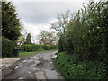
2
Road junction and signpost, Tothill
Image: © J.Hannan-Briggs
Taken: 19 Jul 2011
0.02 miles
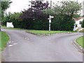
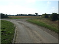
3
Junction of lanes in Tothill
Looking north-westward.
Image: © Peter Wood
Taken: 26 Feb 2019
0.02 miles
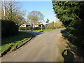
6
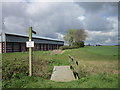
Please keep to the path
A footpath at Tothill
Image: © Ian S
Taken: 14 Apr 2012
0.07 miles
7
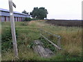
Path to South Reston
This footpath crosses a dyke on this wooden bridge before crossing the fields to South Reston.
Image: © Michael Patterson
Taken: 26 Aug 2006
0.13 miles
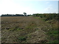
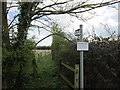
9
Bend in the minor road near Tothill
Farm track (footpath) goes off to the right.
Image: © JThomas
Taken: 11 Sep 2015
0.25 miles