IMAGES TAKEN NEAR TO
Church Lane, ALFORD, LN13 0NG
Introduction
This page details the photographs taken nearby to Church Lane, LN13 0NG by members of the Geograph project.
The Geograph project started in 2005 with the aim of publishing, organising and preserving representative images for every square kilometre of Great Britain, Ireland and the Isle of Man.

There are currently over 7.5m images from over14,400 individuals and you can help contribute to the project by visiting https://www.geograph.org.uk
Image Map (Loading...)


Getting Data...Please wait
Leaflet Map data © OpenStreetMap
Images are licensed for reuse under creativecommons.org/licenses/by-sa/2.0
Notes
- Clicking on the map will re-center to the selected point.
- The higher the marker number, the further away the image location is from the centre of the postcode.
Image Listing (9 Images Found)
Images are licensed for reuse under creativecommons.org/licenses/by-sa/2.0
Image
Details
Distance
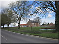
1
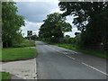
Church Lane in Withern
Looking north-westward.
Image: © Peter Wood
Taken: 26 Feb 2019
0.03 miles
3
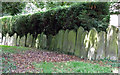
Old Gravestones, Church lane
The old church was converted into a private house. Presumably the gravestones were moved.
Image: © J.Hannan-Briggs
Taken: 19 Jul 2011
0.09 miles
4
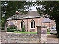
Old Church at Withern
Now a private house
Image: © J.Hannan-Briggs
Taken: 19 Jul 2011
0.12 miles
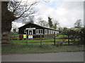
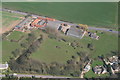
7
Withern Mill trout farm
On the Great Eau. On the left bank are the remains of the terrible flooding that affected the area in July 2007.
Image: © Chris
Taken: 5 Aug 2007
0.18 miles