IMAGES TAKEN NEAR TO
Green Lane, ALFORD, LN13 0DN
Introduction
This page details the photographs taken nearby to Green Lane, LN13 0DN by members of the Geograph project.
The Geograph project started in 2005 with the aim of publishing, organising and preserving representative images for every square kilometre of Great Britain, Ireland and the Isle of Man.

There are currently over 7.5m images from over14,400 individuals and you can help contribute to the project by visiting https://www.geograph.org.uk
Image Map
Images are licensed for reuse under creativecommons.org/licenses/by-sa/2.0
Notes
- Clicking on the map will re-center to the selected point.
- The higher the marker number, the further away the image location is from the centre of the postcode.
Image Listing (6 Images Found)
Images are licensed for reuse under creativecommons.org/licenses/by-sa/2.0
Image
Details
Distance
1
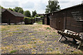
Footpath running through a small farmyard
The footpath continues down the right hand side of the hedge in the centre of the picture, eventually leading to the public road in Aby.
Image: © Andrew Whale
Taken: 3 Jul 2010
0.07 miles
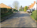
4
New Street, Aby, on a wet September afternoon
Image: © Chris
Taken: 15 Sep 2013
0.17 miles
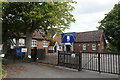
5
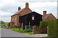
House with outbuildings at Aby
This house lies close to the edge of the village. Its outbuildings are open as if on display.
Image: © Jon Holland
Taken: 14 May 2008
0.22 miles
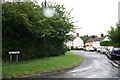
6
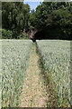
Footpath running through cornfield
The old railway bridge can be seen in the distance.
Image: © Andrew Whale
Taken: 3 Jul 2010
0.24 miles