IMAGES TAKEN NEAR TO
South Thoresby, ALFORD, LN13 0AW
Introduction
This page details the photographs taken nearby to LN13 0AW by members of the Geograph project.
The Geograph project started in 2005 with the aim of publishing, organising and preserving representative images for every square kilometre of Great Britain, Ireland and the Isle of Man.

There are currently over 7.5m images from over14,400 individuals and you can help contribute to the project by visiting https://www.geograph.org.uk
Image Map (Loading...)


Getting Data...Please wait
Leaflet Map data © OpenStreetMap
Images are licensed for reuse under creativecommons.org/licenses/by-sa/2.0
Notes
- Clicking on the map will re-center to the selected point.
- The higher the marker number, the further away the image location is from the centre of the postcode.
Image Listing (51 Images Found)
Images are licensed for reuse under creativecommons.org/licenses/by-sa/2.0
Image
Details
Distance
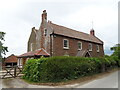
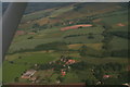
2
Lime Pits Farm
From the footpath from Belleau Bridge to South Thoresby.
Image: © Chris
Taken: 11 May 2013
0.02 miles
4
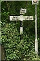
Direction Sign ? Signpost opposite Haugh Lane in South Thoresby
Located on the northwest side of a T junction opposite Haugh Lane in South Thoresby parish. 3 arms and no finial.
Milestone Society National ID: LI_TF4077A
Image: © A Riley
Taken: 4 Jul 2021
0.03 miles
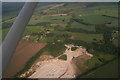
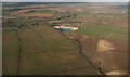
7
South Thoresby Chalk Quarry
Run by Welton Aggregates but for sale as an "Income Producing 46 Acre Chalk Quarry".
Image: © Chris
Taken: 24 Feb 2014
0.09 miles
8
South Thoresby Chalk Quarry
Run by Welton Aggregates but for sale as an "Income Producing 46 Acre Chalk Quarry".
Image: © Chris
Taken: 24 Feb 2014
0.09 miles
9
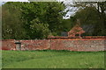
Door in a wall
Old garden wall with pantiles.
Image: © Chris
Taken: 11 May 2013
0.13 miles
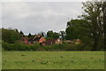
10
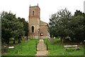
St.Andrew's church
Built 1735-8 on the site of the Medieval church and incorporating a late 14th / early 15th century octagonal font
Image: © Richard Croft
Taken: 18 Apr 2008
0.15 miles