IMAGES TAKEN NEAR TO
Wessex Way, LINCOLN, LN1 2YT
Introduction
This page details the photographs taken nearby to Wessex Way, LN1 2YT by members of the Geograph project.
The Geograph project started in 2005 with the aim of publishing, organising and preserving representative images for every square kilometre of Great Britain, Ireland and the Isle of Man.

There are currently over 7.5m images from over14,400 individuals and you can help contribute to the project by visiting https://www.geograph.org.uk
Image Map
Images are licensed for reuse under creativecommons.org/licenses/by-sa/2.0
Notes
- Clicking on the map will re-center to the selected point.
- The higher the marker number, the further away the image location is from the centre of the postcode.
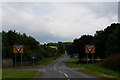
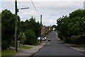
Image Listing (9 Images Found)
Images are licensed for reuse under creativecommons.org/licenses/by-sa/2.0
Image
Details
Distance
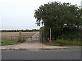
4
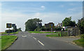
Crossroads near Ingham
The road ahead is Stow Lane.
Image: © David Wright
Taken: 8 Sep 2012
0.10 miles
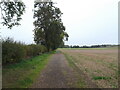
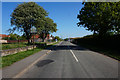
8
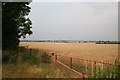
Trent Valley view
View from the edge of the Trent flood plain near Ingham, the darkening sky just a hint of the dramatic summer storm and torrential rain that arrived about an hour ltaer than this picture was taken.
Image: © Richard Croft
Taken: 22 Jul 2006
0.21 miles