IMAGES TAKEN NEAR TO
Church Lane, LINCOLN, LN1 2XW
Introduction
This page details the photographs taken nearby to Church Lane, LN1 2XW by members of the Geograph project.
The Geograph project started in 2005 with the aim of publishing, organising and preserving representative images for every square kilometre of Great Britain, Ireland and the Isle of Man.

There are currently over 7.5m images from over14,400 individuals and you can help contribute to the project by visiting https://www.geograph.org.uk
Image Map
Images are licensed for reuse under creativecommons.org/licenses/by-sa/2.0
Notes
- Clicking on the map will re-center to the selected point.
- The higher the marker number, the further away the image location is from the centre of the postcode.
Image Listing (23 Images Found)
Images are licensed for reuse under creativecommons.org/licenses/by-sa/2.0
Image
Details
Distance
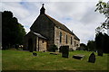
1
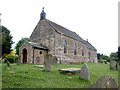
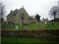
All Saints, Ingham
Rebuilt from a much larger church in 1792.
Image: © Dave Hitchborne
Taken: 25 May 2004
0.02 miles
2
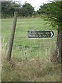
Right of way to Middle Street
A pleasant short walk of 1/2 a mile to Middle Street which in my opinion is a 'Roman Road' of which there are many round these parts.
Image: © Tom Howard
Taken: 30 Jul 2010
0.02 miles
3
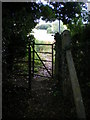
Kissing Gate - Near Ingham
Kissing gate on public footpath to Middle Street 1/2 a mile away. The path here is about to enter a wheatfield.
Image: © Tom Howard
Taken: 30 Jul 2010
0.04 miles
4
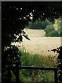
View Over Kissing Gate - Near Ingham Church
The good seed on the land.
Image: © Tom Howard
Taken: 30 Jul 2010
0.04 miles
7
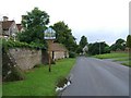
Entering Ingham from the East
Looking along the road into Ingham with All Saints Church in the distance. (A North/South grid line passes directly through the centre of this church - verified using GPS).
Image: © Richard Warren
Taken: 23 Jun 2007
0.05 miles
10
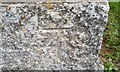
Ordnance Survey Cut Mark
This OS cut mark can be found on the SE face of All Saints Church. It marks a point 36.939m above mean sea level.
Image: © Adrian Dust
Taken: 22 Jul 2017
0.05 miles